Most of the projects carried out in the study of extreme meteorological phenomena, such as a superorned, is aimed at improve their prediction. The simulated event reached sustained winds of up to 320 kilometers per hour, killing 9 people and injuring nearly 200 in its 100 kilometers of route.
The project carried out by the Leigh Orf team of researchers at the Cooperative Institute for Satellite Studies was no different, although the exhaustiveness of the study, and the possibilities of a supercomputer (almost 6 years later) have allowed them to do this simulation.
No scientist has ever seen a simulation of a storm like this before. The help of the Bluewaters supercomputer at the University of Illinois has been decisive in digitally creating the storm that occurred on May 24, 2011. Bluewaters took just over three days to calculate a simulation with all its possible deviations. To get an idea of its capacity, the computer that we can have at home or in the office, would have taken decades.
The supercomputer used the actual weather conditions recorded at the time of the formation and subsequent development of the super tornado. For this, they took into account the temperatures of the air column within the storm, atmospheric pressure, humidity or wind speed.

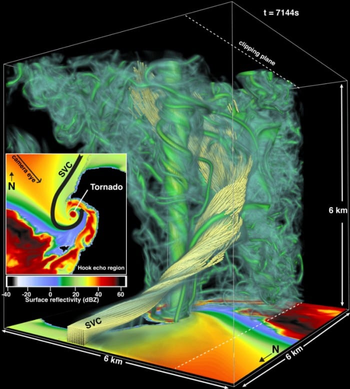
Location and simulation of the Streamwise vorticity current within the tornado
Different parts of the generation and evolution of the tornado are shown in the video. At first you can see the generation of a supercell which is what gives rise to the birth of the tornado. Several of these supercells they generate small tornadoes, which merge giving speed to a main eddy that will end up being the superorned.
At the same time the rain creates a stream of cooled air that seems to act as a kind of siphon, fueling the main phenomenon. The SVC (Streamwise vorticity current) How this air stream is known never touches the tornado, but it seems to be the generator of its force.
The idea of this project is to make a more accurate simulation and put it at the service of other meteorologists so that they can work with it.
Need for this type of study:
What scientists know about these extreme storms and the hurricanes that sweep through Texas, Florida, and the Caribbean, among other places today, is that can occur even more frequently and intensely.
According to a recent study by the American Journal of Climate Change, which effectively analyzes the atmospheric indicators of tornadoes, the simulated supertorning, in a stable climate scenario, it would have a period of recurrence of about 900 years.
But when the researchers take into account factors such as atmospheric instability and the warming of the oceans (both associated with climate change), they confirm that a storm that occurs every 1000 years, it won't take that long to repeat itself.
No researcher can say for sure, to date, how climate change will affect the severity of a single storm. They only know that they have to find out what generates and sustains these storms quickly.
More and better data quality and more powerful supercomputers will help meteorologists elaborate more predictive models.
In this way they could indicate in the path of the tornado, not only that a tornado is approaching, but that type, thus increasing the notice time of the alerts, doing them in turn more accurate and faster.
Lives would be saved and hundreds of families would not suffer any harm.
Ref: Storm chasers