
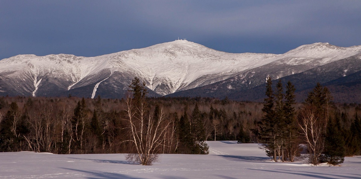
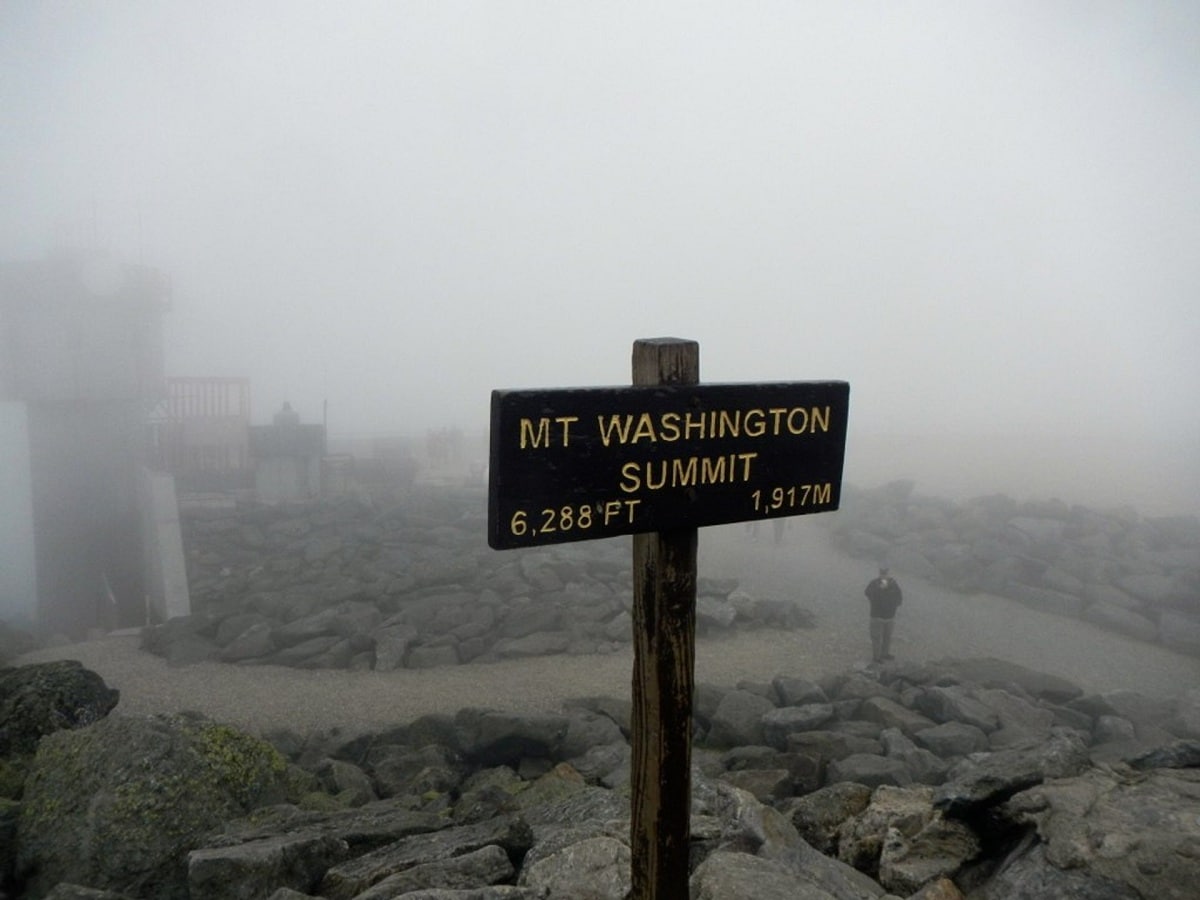
El mount washington, the highest peak in the northeastern United States, at 1.917 meters above sea level, it is the most prominent mountain east of the Mississippi River. He is known for his dangerously erratic timing. For 76 years, until 2010, on the afternoon of April 12, 1934, the Summit Meteorological Observatory held the record for the highest wind gust measured directly at the Earth's surface, 372 km/h or 103 m/s . Before the arrival of European settlers, the mountain was known as Agiocochook, or "Home of the Great Spirit."
In this article we are going to tell you everything you need to know about Mount Washington, its characteristics and origin.
History of Mount Washington
The mountain is located in the Presidential Range in the White Mountains, Sargent Procurement Township, Coos County, New Hampshire. While almost the entire mountain is in the White Mountains National Forest, the 0,24 square kilometer area that surrounds Mount Washington State Park, including the summit.
The first European to mention the mountain was Giovanni de Verrazano. In 1524, he saw it from the Atlantic Ocean, describing what he saw as a "high inland mountain". The Abenakis who lived in the area at the time of European contact believed that the summit was the abode of the gods and therefore, among other things, they did not climb the summit out of religious respect for the gods… Darbyfield claims First ascent of Mount Washington in 1642.
Field scaled the mountain in June of that year, demonstrating to Chief Abenaki Pasakonaway that Europeans were not bound by the gods believed to live on top of the mountain. , a pivotal political move to promote the expansion of northern settlers. In October 1642, Field once again scaled the top of Agiocochook during one of the first reconnaissance expeditions that charted lands as far away as Maine, helping a delegation from the Massachusetts colony seek to occupy the more arable coastal areas.
In 1784, a geological team led by Manasseh Cutler named the mountain. The Crawford Trail is the oldest hiking trail in the United States, paved in 1819 as a horse trail from Crawford Notch to the top and currently in use. Ethan Alan Crawford built a house on top of a hill in 1821 and continued until 1826, the year of a storm.
historical climbs
Little happened to the summit itself until the mid-1852th century, when it became one of America's first tourist destinations, with more horse trails and two hotels under construction. Opened in XNUMX, Summit House is a 20m long stone hotel with a roof secured by four heavy chains. In 1853, the "needle house" was erected for the competition. Rebuilt with wood in 1872-1873, Summit House had 91 rooms, burned down in 1908, and was replaced by granite in 1915.
For forty years, Henry M. Burt published an intermittent journal called Among the Clouds every summer on the summit until 1917. Copies were distributed to surrounding hotels and other stores by rack and stagecoach.
In November 2010, it was revealed that Orlando, Florida-based CNL Financial, which owns the Mount Washington Hotel at the base of the mountain, had officially applied for a trademark under the name "Mount Washington". CNL officials said they were targeting other hotels that use the mountain's name, not the many businesses in the area that use the name. CNL filed an application with the USPTO seeking to register the "Mount Washington" trademark for any retail service, any restaurant service, and any entertainment service.
Geographic characteristics

Although the western slope that the cog railway climbs is a straight line from the foot of the mountain to the top, the other side of the mountain is more complicated. To the north, Great Bay, the mountain's largest glacial ice crater, forms an amphitheater surrounded by the Presidential Mountains to the north: Clay, Jefferson, Adams, and Madison Mountains. These connected peaks stretch well into the treeless alpine terrain. The massive Chandler Ridge stretches northeast from Mount Washington to form the southern wall of the amphitheater and is a freeway ramp.
To the east of the summit, a plateau known as Alpine Gardens extends south from Chandler Ridge some 5,000 feet to the south. It is worth noting that both the endemic plant species of the alpine meadows of the White Mountains and the atypical plant species of the extreme north of the Arctic. Alpine Gardens drops steeply into two prominent glacial craters. Rugged Huntington Canyon offers rock and ice climbing in an alpine setting. More rounded, Tuckerman Ravine is New England's premier jurisdiction for backcountry skiing from spring through June, followed by scenic hiking trails. It is about 500 meters above the alpine tree line.
South of the summit is the second largest alpine plateau, Bigelow Lawn, between 1.500m and 1.700m above sea level. The satellite peaks of the Boott Spur, then Montalban Ridge, which includes Mount Isolation and Mount Davis, extend to the south, while the higher Presidential Mountains (Mount Monroe, Franklin Mountains, Mount Eisenhower, Mount Pierce, Jackson and Webster) they extend southwest to Crawford Canyon and Oaks Bay separates two high ridges.
Hiking Mount Washington
The most popular hike to the summit is via the 6,6-kilometer Tuckerman Canyon Trail. It begins at Pinkham Notch Campground and reaches 4,000 feet, leading directly to the top of the Tuckerman Canyon Bowl through a series of steep rock passages that offer spectacular views of the canyon and through the canyon to Wildcat Mountain. Ski accidents and hypothermia have been fatal along the way. Water bottles can be refilled at the bottom of a pump well 3,4 kilometers from the trail, near a small hiker's shop offering snacks, services, and shelter.
At the top is a center that houses the museum, gift shop, gazebo, and cafe. There is a bus service (summer) back to Pinkham Notch Campground for a fee. Other trails that climb the side of the mountain include the Lion Head, Boot Spur, Huntington Ravine, and Nelson Crag trails, and the Great Gulf Trail that climbs from the northeast. Western Slope trails include the Ammonoosuc Ravine and Jewell Trails and the Crawford Trail and Gulfside Trail (which coincide with the Southwest and North Appalachian Trails, respectively).
There are many differences between climbing Mount Washington in the summer and climbing Mount Washington in the winter. Of course, weather and ground conditions vary widely, but there are also significant differences in the level of service available to visitors. There are no public facilities at the top in winter. In winter, the most popular route is the Lion's Head Winter Route, which begins in Tuckerman Canyon and turns north to climb Lion's Head to 1534 feet above sea level. Route changes are recommended in winter to help climbers avoid avalanche hazards.
Exactly where the trail branches off from the Tuckerman Canyon Trail depends on snow conditions. The Lion's Head Summer Route may be open if the snow is not enough. After a 3,7 km walk from the Pinkham Notch visitor center, trail will turn right onto Lion's Head Summer Trail. If there is enough snow on the Summer Lion's Head Trail, the Forest Service will open the Lion Head Winter Trail and it will finish in about 2,7 miles.
I hope that with this information you can learn more about the bush in Washington and its characteristics.