
In some parts of our planet, we can see a type of surface topography that is covered by silt deposits that have been carried by the wind. This is called loess reservoir. For this type of topography to form, periods of thousands of years have probably had to pass, in which continuous dust storms have deposited this material.
In this article we are going to reveal the importance of the Loess tank and its main characteristics.
Loess reservoir and its formation
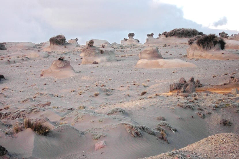
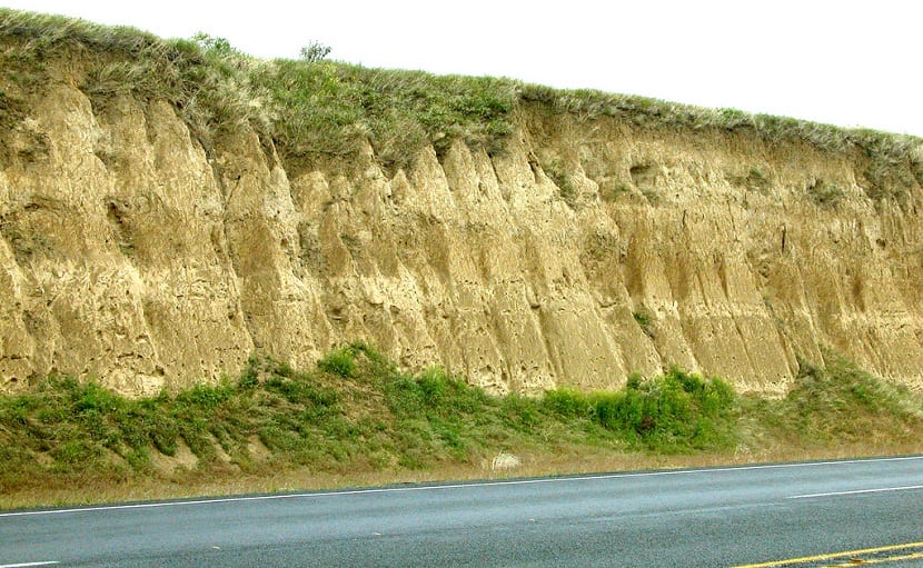
As we have mentioned before, it takes a period of thousands of years for the wind to form these deposits little by little. In some parts of the world we find this type of training and it is a marvel. When the Loess reservoir is traversed by streams of water or cut to make roads, it normally maintains a vertical structure. This is where you do not have visible layers as naturally.
The distribution of the Loess deposit indicates that there are several main sources of sediments for this formation: the first is the desert deposits that accumulate with the force of the wind, and the second is the floodplains of the glaciers. These two sources of training are responsible for the Loess.
The thickest and most extensive Loess deposits on Earth are those we can see in western and northern China. These deposits have been formed by wind transport from the extensive desert basins of Central Asia. Some of these formations are accumulations of 30 meters and it is a common thing to see. In thickness, the average has been established at a size of 100 meters. This sediment accumulates and, for example, it is what provides the color to the yellow river.
On the other hand, in the United States, Loess deposits are more significant in many areas where sediment transport exists over long distances. For example, in South Dakota, Nebraska, Missouri and Illinois, they are areas where we can find these structures. They can also be seen on some of the Columbia Plains in the northwest Pacific.
From

There is a correlation between the distribution of the Loess with the major agricultural regions of the Midwest and the state of Washington. This is not a coincidence at all, but it has a lot to do with it. It is because the soils derived from this sediment that is deposited by the wind are among the most fertile in the world. Thanks to the accumulation of materials, the nutrients also accumulate. It becomes a very fertile area for agriculture.
Unlike what happens with the deposits of China, which have originated in the desert, those of the United States and Europe are indirect products of the glaciations. Freezing and thawing for so many thousands of years, give rise to formations and deposits of sediments that increase the fertility of the soil. On the other hand, those deposits formed by sand sediments are not fertile at all. They only give rise to structures with good landscapes but with little fertility.
The origin of the Loess deposits in the United States and Europe are stratified glacial debris. When the glaciers begin to retreat due to the rise in temperatures, many river valleys have been blocked with sediments that are deposited through the melting water of the ice. In this case, the agent that transports the sediments is not the wind, but the meltwater. The wind has also had its action, since blowing in a westerly direction, it swept and transported many of the sediments that were in the flood plains.
The sediments were transported from the finest to the thickest. In their movement, they have dropped like a blanket on the eastern slopes of the valleys. The origin of these formations can be confirmed by the fact that the Loess deposits are more pronounced in the leeward areas where the main glacier drainage areas are found. For example, it is most appreciated in the areas of the Mississippi and Illinois rivers and they become thinner as the distance from the valley continues to increase.
Another proof of this origin are the angular grains that can be seen weathered and that make up the Loess. It can be seen that they are the same as those that we can find in the rock soil that has been produced in the grinding of glaciers.
Physical characteristics of the Loess tank
These deposits constitute 10% of all soils in the world. The word Loess means that the soil is loose and composed of 50% silt and another 50% clay. As the distances from the emission source increase, the amounts of deposited grains decrease and, therefore, the deposits decrease in thickness and length.
Sources can be local or distant. Hence there are different types of Loess. For example, lime or carbonate are some of the characteristic components that we find in Loess. The type and amount of carbonate that we have depends on the formation process before and after the deposition of the silt and the rain that compacts them.
Being loose, the floors are not too strong. They are firmer when dry, but can still crumble easily when soaked in water. The soil can contain between 10 and 15% water with a porosity that varies between 34 and 60%. These variables change depending on the amounts of clay or sand we have.
As we have mentioned before, they are highly demanded deposits for intensive agriculture. This makes cultivation operations easier and ensures adequate aeration so that the soil has properties and the roots of the crops grow in good condition.
I hope that with this information you can learn more about the Loess deposit.