
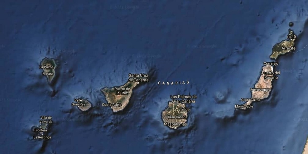
The Canary Islands are an archipelago in the Atlantic Ocean. They are in the northwestern part of Africa and consist of about eight islands, five islets and eight rocks in total. For example, we are talking about La Gomera, La Palma and Tenerife, El Hierro, Fuerteventura, Lanzarote and Gran Canaria. many people wonder How were the Canary Islands formed?
For this reason, we are going to dedicate this article to telling you how the Canary Islands were formed, their characteristics and importance.
How the Canary Islands were formed
These islands are of volcanic origin and are located on the African plate, thus forming the Macaronesia region. They have a subtropical climate, and climate variability translates into biodiversity. All the islands have biosphere reserves, national parks and areas declared World Heritage Sites. Before the pandemic, millions of people visited the islands, for example, in 2019, an estimated 13 million tourists.
Its volcanic origin was also calculated to be fairly recent for the age of the Earth: 30 million years Several theories confirm that the islands were formed in different periods or volcanic cycles, which implies a continuous process of emergence and successive solidification of lava.
Therefore, it can be said that each island of this group has its own geological history or its own antiquity, the oldest islands are probably Fuerteventura and Lanzarote, followed by Tenerife, the Canary Islands and La Gomera. The closest are La Palma and El Hierro, which are less than 2 million years old.
source cycles
So what would this process or cycle look like? First, a phase called the "basal complex" occurs, in which the oceanic crust breaks and the block rises, in which the lava that erupted from the seabed is deposited. Later, the island emerges from the water in a stage known as "underground construction."
In turn, there are two cycles here, the first of the old series forming large volcanic structures, and then the so-called recent series that is maintained today, characterized by permanent volcanic activity. Taken together, we can imagine magma from the planet's interior rising through various cracks in the crust, accumulating on the seafloor, and then emerging at sea level.
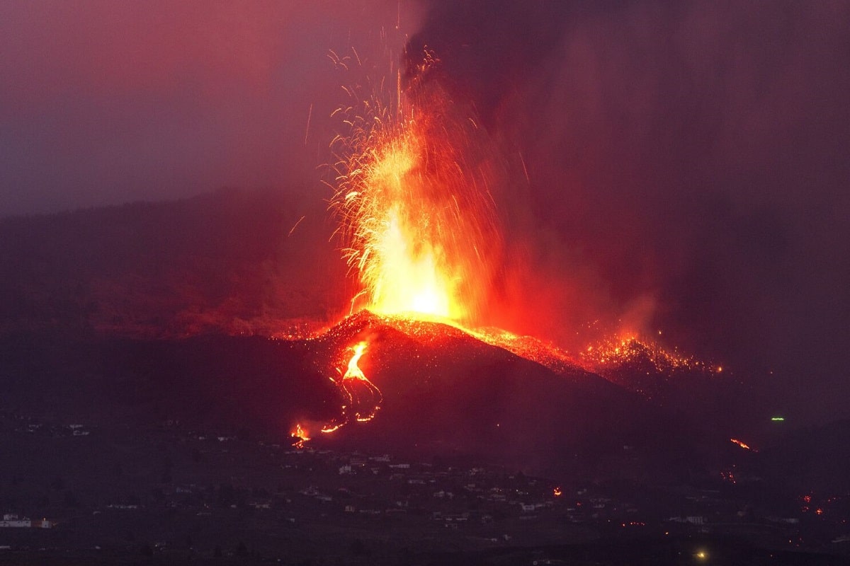
This went on for millions of years and, as we speak, continues to this day with water vapor, sulfurous gases, and occasional eruptions. Take, for example, the eruption of Teneguía on La Palma in 1971 or more recently in 2021, when the nameless volcano terrorized the island for 90 days.
The Canary Islands are mysterious in their own way, and because they are one of the few archipelagos formed by still active marine volcanoes, they are of great interest to scientists. There have been at least 18 eruptions in 500 years, so it has a pretty strong volcanic history, and yes, we haven't seen the end yet.
Theories about how the Canary Islands were formed
The peculiarities of these islands have inspired various theories about their formation. For a time, the hotspot theory prevailed, according to which islands formed in the transoceanic trench between Africa and America. Thus the islands appear in a path, the oldest islands being the furthest from their origin as they progressed along the lithospheric plates.
Another theory is the propagating fracture theory, according to which, following cycles of compression and relaxation of the Atlas tectonic plate, fractures occurred in the lithosphere that spread from the continents to the Atlantic Ocean, Leaving behind the magma.
I have to say that these are all theories and have not been fully accepted, although hot spots are relatively hot. This could explain why the islands are still active, except for some where no volcanic activity is currently recorded. Yes, yes, there are still holes in this explanation, but scientific research continues to try to answer all the questions.
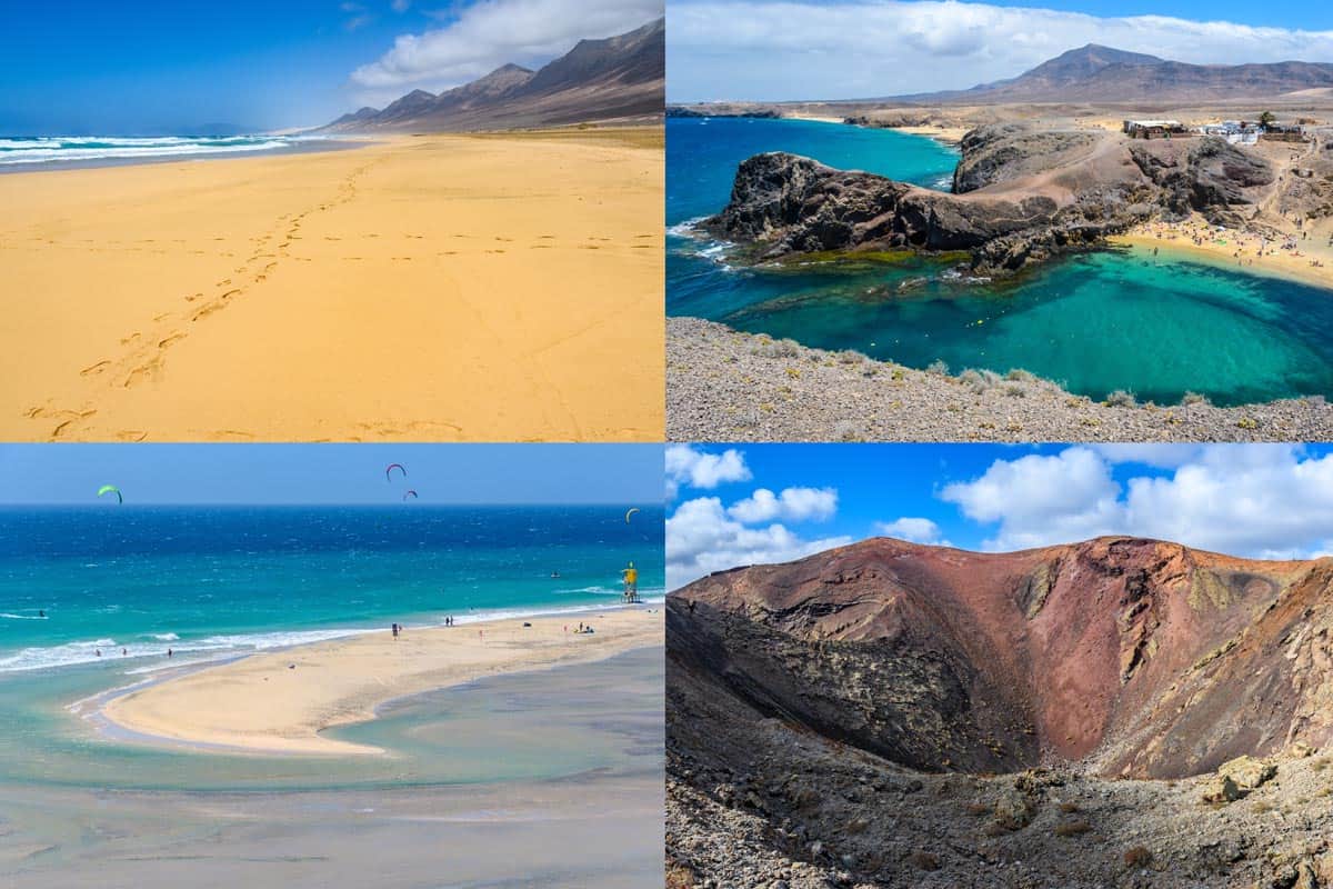
So, what are the characteristics of the beautiful and dangerous Canary Islands? Well, they have all kinds of volcanic rocks that cover the whole range of alkaline basalts and they have all kinds of craters and they are very asymmetric depending on where the wind is coming from and directing the magma in one direction or another, as well as thermoplastic explosions and bombs, the island also has some magma and cones, formations, craters, many volcanic structures between the calderas…
Climate
On the other hand, the islands enjoy a pleasant subtropical marine climate with trade winds due to its proximity to the tropics and the El Golfo current. The wind pushes the clouds to form these beautiful seas of clouds, and it also gives the feeling that the water is almost fluffy and calm.
The Canary Islands is a paradise with an average temperature of 25 ºC throughout the year, so it is a phenomenon at the tourist level.
These are the main characteristics of the islands:
- The Palm: an area of 708,32 square kilometers and a population of 83.458 million. The Teneguía volcano was not in their favor, but last year it had another eruption that wreaked havoc. It is the second highest island in the group, with the highest peak, Roque de los Muchachos, at 2.426 meters. It has the largest optical telescope in the world – the Gran Telescopio Canarias with a mirror diameter of 10,40 meters.
- The iron: It is the smallest island and has its own administration: 268,71 square kilometers and only 11.147 thousand inhabitants. This is a biosphere reserve where a large underwater eruption occurred ten years ago. It is the first island in the world to be self-sufficient with renewable energy.
- Tenerife: The largest island, 2034,38 square kilometers. It is also the most populated region with 928.604 thousand inhabitants. Known as "Yongquan Island", it has beautiful beaches and numerous natural parks. Yes, it is the place that receives the most wealthy tourists every year.
- Gran Canaria: It is the second most populated island in the archipelago. With an area of 1560 square kilometers, it is round and mountainous. It has valuable archaeological sites and diverse landscapes that range from golden beaches, through desert landscapes to green areas.
- Fuerteventura: 1659 square kilometers, the closest to Africa. It is also the oldest, geologically speaking, and the most eroded. It has been a biosphere reserve since 2009.
- Lanzarote: It is the easternmost island and the oldest of all the islands. The surface is 845,94 square kilometers, and the capital is Arrecife. It has volcanoes and has been a biosphere reserve since 1993.
- The Graceful: Until recently it was just a small island, but today it is an island, the eighth inhabited island in the archipelago. It is only 29 square kilometers and is inhabited by 751 people.
I hope that with this information you can learn more about how the Canary Islands were formed and their characteristics.