
Spain has numerous rivers that belong to different river basins. The largest river in all of Spain is the Ebro river. It is a river whose basin is located in the Northeast of the Iberian Peninsula, bordering the North, the Duero, the Tagus, the Jucar and the Eastern Pyrenees basins, in addition of those corresponding to the French slope. It is the best known in all of Spain and has a great flow. Its mouth forms a delta and is known as Ebro valley.
In this article we are going to tell you everything you need to know about the characteristics, geology and formation of the Ebro valley.
Key features

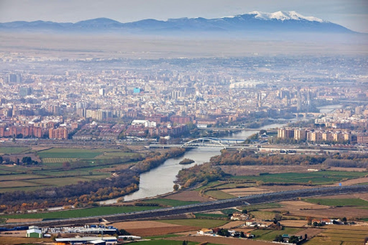
The Ebro Valley or Ebro Depression is a vast area in the northeast of the Iberian Peninsula, where the Ebro River flows. The river originates in the Cantabrian Mountains and empties into the Mediterranean Sea. The Ebro Valley is bounded by the Pyrenees to the north, the Iberian System to the south and the Catalan coastlines to the east. The river depression is located near the river itself in the northeastern part of the Iberian Peninsula.
From the Sierra de Híjar to Tortosa it has a surface approximately 40.000 square kilometers and a length of 840 kilometers. It passes from west to east through the Autonomous Community of Cantabria, Burgos and Soria to the east of Castilla y León, to the south of the Basque Country in Álava, La Rioja, Navarra, The communities of Aragon, Catalonia and Valencia are to the north of the province of Castellón, ending in the Mediterranean. In its northern limit are the Pyrenees, in the east it borders with the Catalan Coastal Mountain Ranges, and in the south and west with the Iberian system.
The depression has an average elevation of 200 meters and is surrounded by large elevations. The mouth is known as Delta del Ebro, a protected area classified as a Natural Park. It has deposits of marine and continental conglomerates, which are thick at the edge of the mountain and not too thick in the center of the depression: sandstones, marls, gypsum, salts and limestones. The difference in the hardness of the material and the arid climate have led to different geographical features.
The river is located in the fault between the Iberian Peninsula and the European continent, it coincides with the old seabed and later it was transformed into a lake, intermittently separating the Iberian Island. The Iberian Peninsula is connected to Africa and Europe.
Uses of the soil of the Ebro valley
The best agricultural use of the Aragonese soil is located in the central depression, where there is the largest and most productive irrigated and rainfed area for the planting of cereals and vines. These plantations constitute the base of the agrarian economy of Aragon. On the other hand, these spaces are the most used and coveted in history, dating back to pre-Roman times.
Rainfed grain monoculture represents a very suitable land use system for sterile environmental conditions outside the irrigated area. The substitutes for wheat-barley and, to a lesser extent, oats and ryeThey depend on the support of the central government and the quality of the land. Cereal farming was completely mechanized and fallow was still used in most areas of the Depression.
The monoculture of grains occupies a compact space in the glaciers and hills of the Ebro valley and the low calcareous platform in the south of Los Monegros. The only limiting obstacle is the gypsum outcrop around Zaragoza. It is a site that cuts in large numbers through a dense network of narrow valleys, which are grasslands territories for espartos and pilgrims, and constitute the true desert islands in the center of Depression. The occupation of the ground is limited to the flat bottoms of the vouchers, where the accumulation of silt offers good soils and concentrates the little humidity.
Climate and geology of the Ebro valley

Throughout the Ebro valley we can find a great heterogeneity in the climate due to the great extension that already has the participation of influences of the meteorological variables of both the Mediterranean area and the continental area. We can broadly differentiate three main climatic zones:
- Cantabrian area: It is that area that has abundant and uniform rainfall throughout the year. Mild temperatures predominate so they do not have too many sudden changes.
- Central depression: It occupies 80% of the Basin and has a decisive influence on the semi-arid climate with seasonal rainfall. These precipitations are distributed in the rainy and dry seasons.
- Mediterranean area: scarce rainfall and milder temperatures predominate in it due to the proximity of the sea.
Temperatures tend to reach highs of 26 degrees in the hottest months and lows of -4 in the winter months. Most of the precipitations take place in the mountainous systems that delimit the valley of the Ebro. Said precipitations they reach values of 1800mm / year in the Pyrenees. However, in the central part of the valley the values are much lower, reaching below 400mm / year. The average annual precipitation of the entire Basin is approximately 590 mm.
As for geology, it also has a very varied geology as well as the climate. Materials predominate limestone-dolomitic, Cenomanenses-Turonenses, Triassic limestones and dolomites and detrital materials. As expected, in this valley there are aquifer systems in the southern zone of the Basin that have detrital formations that are typical of successions of stands and sands with intercalations of silts and clays. These are of variable potential and carbonated in nature.
Some curiosities
- The total contributions of the Basin are comprised between 17.500 and 19,000 hm3 / year for the different uses.
- The contribution of groundwater has been estimated at 3.730 hm3 / year, of which just over 3.300 hm3 / year are discharges to the Ebro river.
- The total population of the Basin is 2.850.000 inhabitants, with an average density of 33.3 inhabitants / km2, a value much lower than the national average.
- Mainly small urban centers predominate, 90% of them having a population of less than 2.000 inhabitants.
I hope that with this information you can learn more about the Ebro valley and its characteristics.