
El Strait of Gibraltar It is the arm of the sea that separates Africa from Europe and connects the waters of the Atlantic with the Mediterranean. It is also located in a fault zone between the Eurasian and African tectonic plates. It has great economic and fishing importance. Throughout history it has been well known.
For this reason, we are going to dedicate this article to telling you about all the characteristics and importance of the Strait of Gibraltar.
Key features
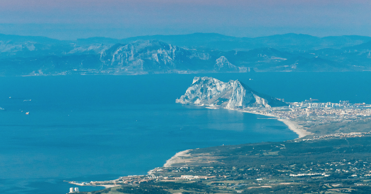
The maximum depth of the Strait of Gibraltar is 90 meters. The distance between the two closest points on both sides of the strait (Punta de Oliveros in Spain and Punta Cires in Morocco) is 14,4 km.
The current name of the strait refers to the Rock of Gibraltar, located on the Iberian Peninsula, although under British sovereignty. The word Gibraltar comes from the Arabic place name Djebel Tariq, which means "Tariq Mountain", the name of the Muslim leader who led the conquest of the peninsula in 711 AD.
In ancient times, this place was known as the "Pillar of Hercules" and marked the limits of the world known to the ancient Greeks. The North Pillar is traditionally identified as the Rock of Gibraltar (426 m), while the South Pillar may be Mount Jacho (204 m) in Ceuta (Spain) or Mount Moussa (851 m) in Morocco.
There are 3 countries that control the area of the strait: Spain, which occupies the north coast, with the enclave of Ceuta on the south coast; Morocco, which controls the southern coast, and the United Kingdom, which owns the territory of Gibraltar on the northern coast.
Climate of the Strait of Gibraltar

The geographical pattern of the Strait of Gibraltar determines some peculiarities of its meteorological conditions. According to the Köppen classification, the area has a hot dry climate (Csa), characterized by hot summers and low rainfall, especially on the south coast (between 500 and 700 mm per year).
The average temperature in winter ranges between 8ºC and 12ºC, while in summer it is around 25-28ºC. The layout of the reliefs helps to guide the winds on the east-west axis, which can blow in one direction or another. In the central part of the Strait of Gibraltar, these winds can reach 40 to 50 knots. The current is very strong. On the surface they flow from the Atlantic to the Mediterranean, while in deeper waters the opposite movement occurs.
Historically, the Strait of Gibraltar has had enormous strategic and commercial importance and continues to this day. As a transit point between the Mediterranean Sea and the Atlantic Ocean, the Strait of Gibraltar is one of the busiest shipping lanes in the world, along with the Suez Canal, the Strait of Hormuz, the Panama Canal and the Strait of Malacca. The north-south direction is also important, that is, the maritime traffic between Europe and Africa. The most important ports are:
- On the North Slope: Gibraltar (United Kingdom), Algeciras and Tarifa (Spain).
- On the southern slope: Ceuta (Spain), Tangier and Mediterranean Tangier (Morocco).
In addition to this, the Strait of Gibraltar is one of the most important illegal immigration channels in Europe, and therefore one of the most talked about.
Geography and geology of the Strait of Gibraltar

It is a natural barrier between two countries: Spain and Morocco; between two continents: Europe and Africa; between two seas: the Mediterranean and the Atlantic; between two religions: Christianity and Muslims; between two cultures: West and East. Even geologically, the strait represents a rift in two tectonic plates: the Eurasian plate and the African plate. The depth of the middle of the strait is 1400 meters. Nowhere in the world is there so much contrast in such a short distance.
geographically, the strait begins in the west between Cape Trafalgar and Cape Spartel, and is bounded on the east by the Rock of Gibraltar and Mount Hacho de Ceuta. In the Ribera Norte, the city of Gibraltar and the southern part of the province of Cádiz will be described, as well as the regions of Campo de Gibraltar and Lajanda, and Cádiz will be cited as the capital of the province.
In the south we will describe the municipality of Ceuta and Tangier-Tetouan in the northern part of the Moroccan region, as well as Fnideq-Mdiq, Anyera, Fash Beni Maqada, Tangier-Asilah and the province of Tetouan, citing Lalash and Jon, although far of the area, has a lot to do with the strait.
The Strait of Gibraltar, which separates Europe from Africa, It is just over 10 kilometers, slightly longer than Mount Everest, which is about 9 kilometers above sea level. This is the altitude at which commercial airliners fly and is therefore the furthest point from land for most people. As we all know, Mount Everest is the highest point on earth, although it is not the highest mountain. In Hawaii, the summit of Mauna Loa rises about 4 kilometers above sea level, but its slopes plunge to the bottom of the ocean with a total height of 10 kilometers.
Relief, flora and fauna
The Strait of Gibraltar is a place with absolutely exceptional climatic conditions, which extends over tens of kilometres. The reliefs direct the wind in two different directions: west and east, that is, downwind or vice versa. accelerate violently, hitting 40 and 50 knots near the rocks. However, it may or may not be loose before or after 20 miles. Crossing the strait is not particularly strategic, but crews must anticipate sudden changes in wind direction so as not to lose time.
It has the highest road in Europe at 3.478 meters above sea level and the Guadalquivir Valley (which means great valley in Arabic), the river that flows from east to west, where the cities of Seville and Córdoba meet.
The estuary is the largest protected natural park in Europe (Doñana), where you can admire the last specimens of the Iberian lynx, golden eagle, roe deer, wild boar and countless birds of all sizes on their migration from Africa to Europe. They nest in the park during the journey.
The funnel shape of the Strait of Gibraltar and the coastal massifs on both sides of the Strait often generate very strong winds. This has benefited the development of wind power and spawned endless forests of windmills and windsurfing. Tarifa, located in the southern tip of Spain, has hosted several World Championships.
I hope that with this information you can learn more about the Strait of Gibraltar and its characteristics.
The topics you have contributed are very interesting and knowledge-enriching… Greetings