
El Seine river, or Seine in French, is the most important river in France, both for its routes, commercial and tourist wealth, as an inseparable symbol of the fame that accompanies the multifaceted Parisian life. It is 774,76 km long and empties into the Paris Basin, especially Troyes, Paris, Rouen and Le Havre. It rises in Source-Seine, 446 meters above sea level, on the Langres plateau in the Côte-d'Or. The general direction of its course is from southeast to northwest. The Seine empties into the English Channel between Le Havre and Honfleur. Its hydrological basin covers 79.000 square kilometers and covers almost 30% of the country's population.
In this article we are going to tell you everything you need to know about the Seine River and its characteristics.
Birth and location
The Seine is a European current on the Atlantic slope, located in northern France. It starts at about 470 meters above sea level, located on the Langres plateau, near Dijon, Côte d'Or, and runs northwest through the cities of Troyes, Fontainebleau, Paris and Rouen (Rouen) until it reaches at its mouth in the wide estuary between Havre and Honfleur, northwest, Seine Bay, English Channel.
The Seine River is the second longest river in the country, after the Rhône (although part of it runs through Swiss territory), with a total length of 776 kilometers. Its basin has an area of 78.650 square kilometers and it is mostly within the Bassin parissien or Parisian Basin, which is basically a sedimentary basin in the form of a basin open to the English Channel from the geological point of view.
The basin includes geological formations that converge centrally along steep slopes, with significant aquifer formations interposed between them. Its topography generally does not exceed 300 m, except on the southeastern coast at Morvan Heights, where it reaches a maximum of 900 m.
As we mentioned earlier, the Seine river rises about 470 meters above sea level. The Seine is navigable from Bar-sur-Seine, more than 563 kilometers from its mouth, for small boats and other vessels with greater cargo capacity, to Rouen, about 121 kilometers from its mouth.
Water regime of the Seine river
The Paris Basin has an oceanic climate, with prevailing westerly winds bringing a constant flow of moisture. Coastal areas receive between 800mm and 1100mm of precipitation. Due to the lack of topography, the elevation drops to 550mm in the central region, Bosch is the lowest, the eastern edge rises, and Mofan tops out at 1300mm.
The Seine and its three main tributaries, the Aubert, the Marne and the Oise, flow through areas with similar characteristics (ocean conditions, low topography and the same geology). They share the same hydrological regime, with the highest flow in January and the lowest in August.
The Paris basin includes nine aquifers interposed between different geological layers. The hydrological network is directly connected to the shallower aquifer at various points. Depending on the height of the water, feeds the Seine or is fed by it. Finally, the alluvial formations less than 10 meters thick in the valley constitute the tenth most productive aquifer.
Although the rains are well distributed throughout the year, the Seine and its tributaries can experience severe periods of low tide in late summer or, conversely, severe flooding in winter. There are two types of floods: flash floods in the upper part of the basin after heavy rains and slow floods in the lower valleys after prolonged rains.
Seine river basin

Basin, including part of Belgium, is 78 square kilometers (30 square miles), of which 470% is forest and 2% is arable land. In addition to Paris, there are three other cities in the Seine basin with a population of more than 78 inhabitants. They are Le Havre at the mouth of the river, Rouen in the Seine valley and Reims in the far north, with an annual urban growth rate of 100.000%. The population density is 0,2 inhabitants per square kilometer.
Paris' sewer system periodically experiences failures known as sewer overflows, usually during heavy rains. In these conditions, raw sewage was dumped into the Seine. The resulting lack of oxygen is mainly caused by non-native bacteria larger than one micron.
The Seine has relatively high concentrations of heavy metals. The pH of the Pont Neuf Seine was measured at 8,46. Even so, the quality of the water has improved significantly compared to what various historians have called "open sewers" at various times in the past.
Flora and fauna
Most of the Seine passes through industrialized or highly developed areas, so its flora and fauna decrease. However, the waters are still home to fish such as flounder (Lota lota), pike (Esox lucius), minnow (Phoxinus phoxinus), perch (Perca fluviatilis), European flounder (Platichthys flesus), common sturgeon (Acipenser sturio), Tinca tinca, white snapper (Blicca bjoerkna), loach (Cobitis taenia), otter (Barbatula barbatula), eel (Anguilla anguilla), river lampe (Lampetra planeri), river lamprey (Lampetra fluviatilis) and even the sea lamprey (Petromyzon marinus), visiting brackish or fresh water from the sea. Acipenser sturio is rare or may have disappeared in rivers, and Atlantic salmon (Salmo salar), which disappeared from the waters in the early XNUMXth century, appears to be making a comeback.
The topography of the Seine Valley has not changed much, with an estimated 2% covered by forests and 78% cultivated. Since Burgundy is a wine-producing region, near its source, the land is dominated by vines. Beyond the access road to the city, the coast is home to some aquatic plants, of which reeds stand out.
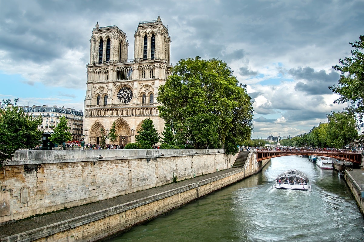
The importance of the Seine, in addition to the economy, culture and history. It is an easily navigable river due to its calm waters, low elevation with respect to sea level and the construction of dams and reservoirs. In Paris, it forms a waterway and the city's drainage network carries most of France's river traffic. Le Havre is the main port in the north of the country, at the mouth of the river, so Paris is directly connected to the port. The Seine passes through 37 Parisian bridges and several bridges outside the city.
I hope that with this information you can learn more about the Seine River and its characteristics.