
In some frontal meteorological systems that travel at high altitudes, it is possible to observe the tracing of lines on the map that are apparently not well understood by the general public. These types of lines are sometimes used in excess to explain the precipitation fields and pressures that are predicted on the earth's surface. These lines are known as troughs. Most people don't know what is a trough and what it represents.
Therefore, we are going to dedicate this article to tell you everything you need to know about what a trough is, its characteristics and types.
What is a trough
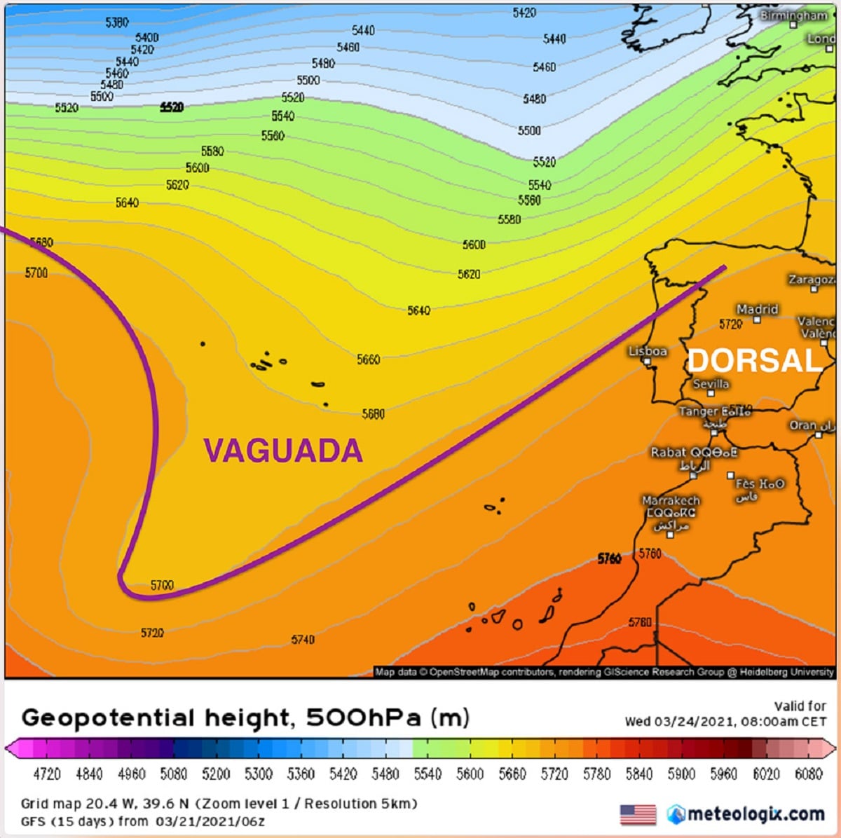
There are different definitions within the scientific literature of what a trough is. We can say that it is an elongated area of low relative pressures on the surface or at high levels. It is not generally associated with a closed circulation, and is thus used to distinguish it from a closed low. The opposite is the dorsal. This definition more closely resembles the concept of a dynamic or barometric trough. In these cases, it is enough to look for minimum atmospheric pressure surface or height where the depression isolineas do not close to draw a trough.
Along with the conventional trough, the concept of inverted water emerges. It is the one in which the isobars, which are the lines of equal pressure, they present a different orientation than normal cheese with respect to the main depression. The inverted trough can be said to extend north from the bottom of the depression.
The trough concept is related to atmospheric pressure, temperature or wind fields but never to precipitation or meteorology at that time.
Types of troughs
Let's see what are the main types of troughs that exist:
- Barometric trough. Relative to adjacent areas at the same level, an area of the atmosphere with lower air pressure. It is represented by isobars or system of isobars almost parallel and approximately V-shaped in the meteorological table, and its concavity points towards low pressure.
- Dynamic trough. The depression forms behind a mountain range that passes vertically or almost vertically through the wind. For example, this happens when the west wind meets a chain of terrain from north to south.
- Stray in the easterly winds. Low pressure zone in the zone of the trade winds, generally perpendicular to the wind current and moving from east to west.
- Watered in the westerly winds. Watered in westerly winds in mid-latitudes, generally moving east. The extension of this trough in the easterly winds of the low latitudes is associated with the westerly winds in height, above the easterly winds of the lower layers.
- Cold trough. An air pressure trough in which the temperature is lower than the adjacent area.
- Polar trough. Watered in a circumpolar western zone wide enough to reach high altitude tropical areas. The surface is related to low pressure valleys in tropical easterly winds, but westerly winds appear at moderate altitudes. It generally moves from west to east and is accompanied by abundant cloud cover at all levels. Dense cumulus clouds and cumulonimbus tend to appear on and near the valley line. June and October hurricanes in the western Caribbean often form in the polar valleys.
We can continue to view and analyze the glossary without drawing firm conclusions. In all the reference definitions, the spatial or temporal terms that link the existence of valleys with small spatial and temporal structures do not appear, although this is implicitly considered: the valleys are subtemporal structures, which in principle do not indicate the surface of time. To understand what a depression is, we will discuss a series of preliminary basics.
Front systems
Fronts are clearly defined spatial and temporal discontinuities between air masses that occur in mid-latitudes and are related to extratropical storms. Roughly, its longitudinal spatial dimension and its life cycle make it fall within the so-called meteorological scale. Its graphic representation is well known and easy to identify.
We have a clearly defined front, which is the discontinuity between two air masses with different meteorological characteristics in terms of temperature, humidity, wind, etc. The most common front at the meteorological level begins having a three-dimensional structure, so the discontinuity reaches a moderate level, for example up to 700-500 hPa. The classical fronts (cold fronts, warm fronts, and occlusive fronts) are nothing more than a mechanism by which the atmosphere redistributes vertical and horizontal gradients of temperature and humidity between warm tropical and subtropical latitudes and cold polar latitudes. They are related to extratropical storms or cyclones and have a climatic dimension. The front is related to characteristic climatic changes.
If a front system has no surface reflections, the front is said to be tall. In some cases, these positive structures have their own frontal symbolism, although some draw them as troughs.
Troughs and lines of atmospheric instability
Under certain conditions, troughs are drawn as elements related to the non-frontal precipitation structure of the hottest months, which are basically formed by convective foci that evolve day and night. These hypothetical depressions drawn on the weather map are intended to support the cloud field, especially the predicted or analyzed precipitation field, which is often interpreted as a line of meteorological change or deterioration due to convection. The point is, these unstable lines are sometimes supported by highly dynamic and thermal dips and low-level temperature peaks, all of which can create an environment conducive to convection. In this sense, depressions are often drawn behind the precipitation / cloud cover line, which is related to climate changes related to convection and storms.
I hope that with this information you can learn more about what a trough is and its characteristics.