
We have all seen a map of coordinates where there are marked meridians. There are many people who do not know well what are meridians. Meridians and parallels are two imaginary lines by which the world is usually organized geographically. With them, a coordinate system is established that allows the precise location of any point on earth based on its latitude and longitude.
In this article we tell you what the meridians are, what their characteristics are and their importance.
what are meridians
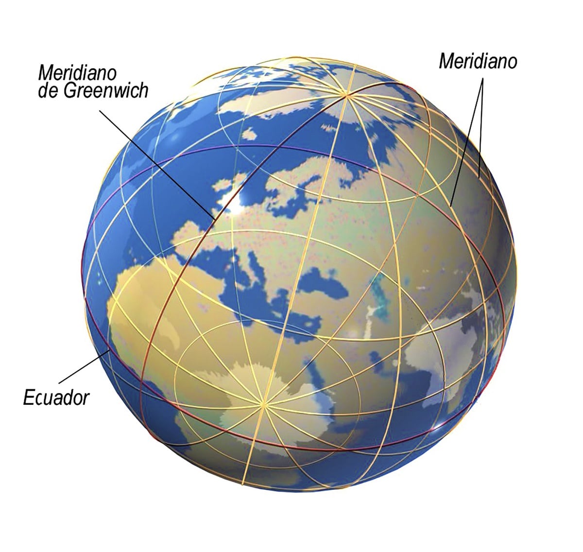
Specifically, the meridian is the vertical line that we can divide the Earth into equal parts. They all start at the North Pole and spread to the South (and vice versa). Parallel lines, on the other hand, are the same horizontal lines. The parallel line 0 is the equator. Repeat the other similarities by drawing smaller circles in the northern and southern hemispheres. The combination of these two sets of lines forms a grid.
Both types of lines have a reference point from which lines of longitude and latitude can be enumerated, using sexagesimal (denoted as follows: degrees°, minutes, and seconds):
- Meridians. They are measured at the rate of each angle (1°), starting from the so-called 0° meridian or Greenwich meridian, the exact location across London where the Royal Greenwich Observatory once stood. From there, the meridians can be considered east or west, depending on their orientation with respect to that axis, and the earth is divided into 360 segments or "gajos".
- Parallels. They are measured from the equator, taking into account the angles they form with respect to the Earth's axis of rotation: 15°, 30°, 45°, 60° and 75°, all in the northern hemisphere (eg, 30 °N) , such as south (30° S).
Applications
The application effect of this system becomes:
- Time zone system, determined by Meridian. Currently, the GMT format (Greenwich Mean Time, “Greenwich Mean Time”) is used to represent the time in any part of the world, adding or subtracting hours according to the meridian that governs each country. For example, Argentina's time zone is GMT-3, while Pakistan's time zone is GMT+5.
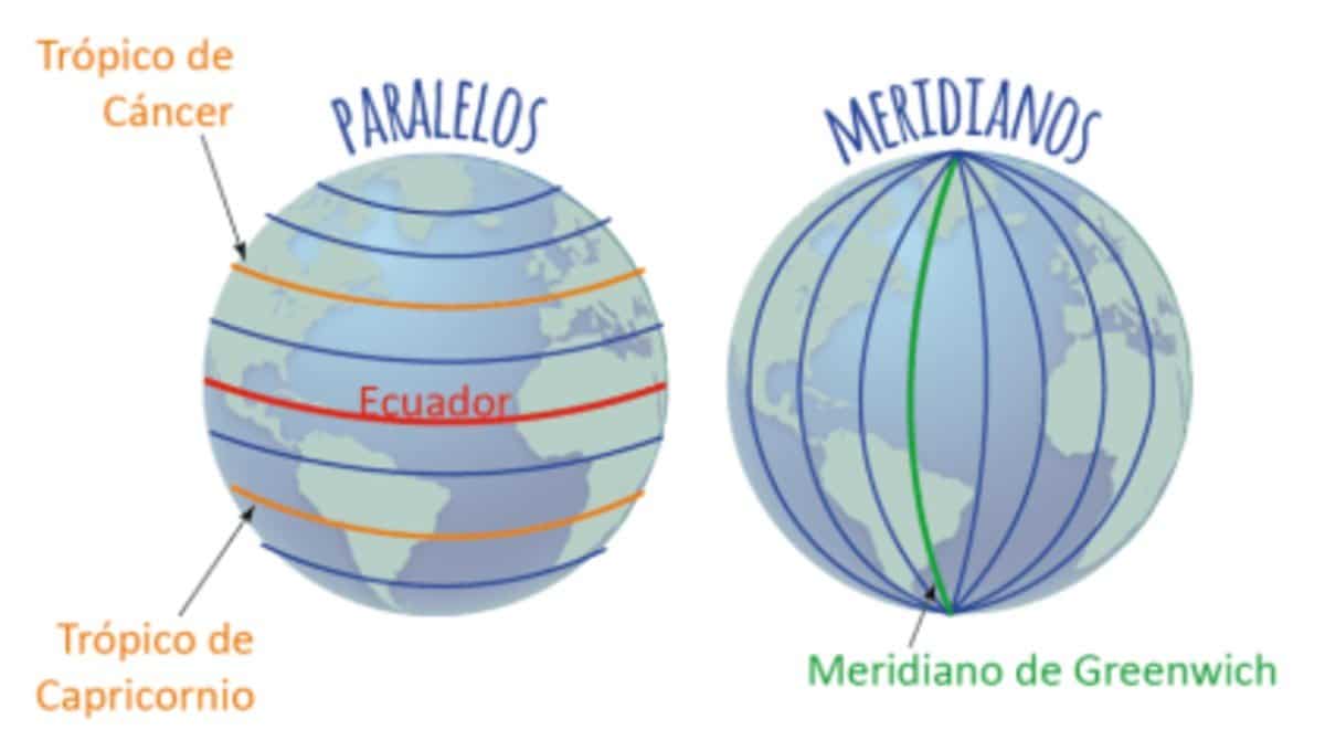
- Earth's climate system, determined by parallel lines. Of the so-called five distinct parallels, they are (from north to south): Arctic Circle (66° 32' 30» N), Tropic of Cancer (23° 27' N), Equator (0°), Tropic of Cancer (23 ° 27' S) and the Antarctic Circle (66° 33' S), the Earth is divided into climatic or geographical astronomical zones, which are: the tropics, two temperate zones and two glacial or polar zones. Each one has similar climatic conditions due to its latitudinal location.
- Global coordinate system. This allows the use of geolocation tools such as GPS (Global Positioning System, “Global Positioning System”).
As we saw in the previous case, a grid arises from a combination of meridians (longitudes) and latitudes (latitudes). The geographic coordinate system consists of the representation of the value of a geographic point from its numerical record of latitude and longitude in sexagesimal.
For example, the geographical coordinates of Moscow are 55° 45' 8" N (that is, its latitude in the northern hemisphere is between the 55th and 56th parallels) and 37° 36' 56" E (that is, its longitude) is located between parallels 37 and 38 between the warps). Today, satellite positioning mechanisms such as GPS operate with the system.
Greenwich Meridian
The best way to get to know the Greenwich Meridian is to go to London, who was born at the Royal Greenwich Observatory, south of the British capital. The area is little known, but it is an ideal holiday destination for a trip to London in 3 days. The Royal Greenwich Observatory is a reference point for understanding when and why the Greenwich Meridian appears.
The Royal Greenwich Observatory held an exhibition on the importance of time, how the meridian was designed, and subsequent agreements by countries around the world to establish a time schedule through it. Also, from the promontory where the observatory is located, you can see an unusual view of London (as long as there is a sunny day).
Greenwich meridian is used to mark universal standard time. This is a convention, and it was agreed upon in Greenwich, because at the World Conference held in 1884, it was determined to be the origin of the zero meridian. At the time, the British Empire was in its greatest period of expansion, and it was required to do so. If the empire at that time were different, today we would say a different place, like the zero meridian. Starting from the Greenwich meridian, the time zone applicable to each country and region is set.
The situation in European countries is strange because there are several time zones on the European continent, but according to Directive 2000/84, the countries that make up the European Union decided to keep the same time in all time zones to promote political and commercial operations . This tradition has been applied in many countries since the First World War, when it was used as a way to save fuel. But the Greenwich meridian is always used as a reference.
The time change in winter occurs on the last Sunday in October and involves moving the clock forward one hour. On the other hand, the time change in summer occurs on the last Sunday in March, which means moving the clock forward one hour.
The birth point of the Greenwich meridian is London. As we pointed out earlier, this meridian connects the North and South Poles, thus spanning multiple countries and multiple points. For example, the Greenwich meridian passes through the Spanish city of Castellón de la Plana. Another sign for the passage of the Meridiano is found in the 82.500 kilometers of the AP-2 motorway in Huesca.
But, in fact, the Meridian runs through almost the whole of eastern Spain, from its entry into the Pyrenees to its exit through the El Serrallo refinery in Castellón de la Plana.
I hope that with this information you can learn more about what meridians are and their characteristics.