
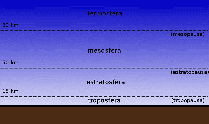
Everything we call meteorology and the different types of weather they occur in the troposphere. That is, in only one of the layers of the atmosphere. The troposphere is the area of the atmosphere where we live and that has its end between 10 and 16 km high. Above this area is the stratosphere. The limit that marks both layers is the tropopause. This is the subject of this article.
The tropopause has differential characteristics between the layers it separates and is what makes the climate end up line. In this post we tell you all about the tropopause.
Key features
It is a discontinuous zone between the troposphere and the stratosphere. As we well know, the troposphere is the area where the different types of clouds and precipitation takes place. Above this layer, the characteristics, composition of gases and other factors of the atmosphere change completely. For example, in the stratosphere is the well-known ozone layer It protects us from the harmful rays of the sun.
The tropopause is the one that marks the upper limit of the presence of water vapor in the air. From this height level, the air is completely dry. One of the characteristics that this limit represents is that it supposes a thermal inversion. That is, the temperature in the stratosphere increases with height instead of decreasing. This stops all vertical air movements in addition to the force of the horizontal winds of the stratosphere.
The temperature gradient of increase of thermal inversion is 0,2 degrees per 100 meters. Contrary to popular belief, the tropopause is not a continuous layer. Quite the opposite. As we move into mid-latitudes and the tropics, we can see some breaks in both hemispheres. The curious thing about it is that these ruptures coincide with the trajectories that the jet stream.
The openings in the tropopause allow the ozone present in the stratosphere and the rest of the dry air to enter the troposphere. The altitude values of the tropopause descend in the areas from the equator to the poles. However, the temperature increases with altitude.
Types of tropopause according to altitude and latitude
Depending on the meteorological and weather variables at each moment, the height of the tropopause varies. For example, it is higher when there are anticyclones in the lower layers and it is lower when there is a depression or a storm. The temperature changes depending on the latitude where you are. There are areas where it is at -85 ° C and in other areas at -45 ° C.
In this way, three different conditions or three types of tropopause can be identified, depending on the area where it is as well as the latitude and altitude.
- Type 1 or normal It is one that has predominantly stationary situations. There is no warm or cold advection in the troposphere.
- Type 2 or H It is also called the high tropopause. It is the one that signals when there is a type of warm advection in the upper and middle zone of the troposphere. This usually happens in the presence of warm anticyclones.
- Type 3 or S. Also known as sunken. It corresponds to when a cold advection has originated in the upper layers of the troposphere and the rest is formed when there are areas of low pressure in the lower layers.
Importance
Although it may not seem like it, this line that separates both layers of the atmosphere is of great importance for life on Earth. The first thing is that thanks to the stability it provides at high levels, the famous cirrus clouds.
Serves as a water reservoir, since it is capable of storing a lot of water vapor in its lower limit from tropical areas. Many of the compounds present in this limit serve to better understand the effects of climate change and how it will affect the planet. This is how other plans can be designed to mitigate some of the most dangerous damage caused by the phenomenon.
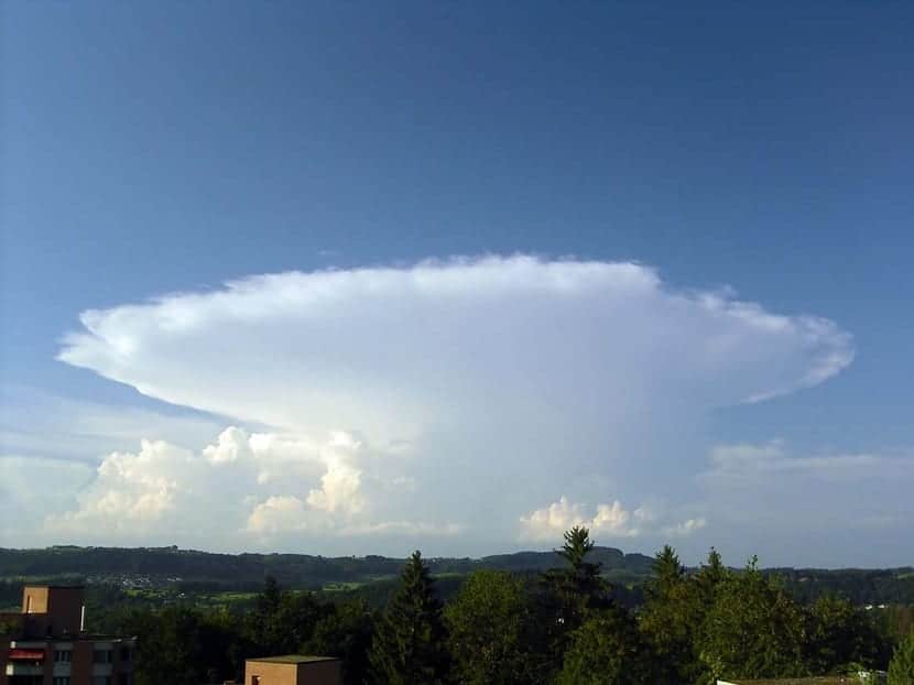
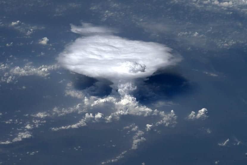
The clouds that reach the tropopause by convection currents stop rising and it is as if they run into a glass wall. Don't let the clouds keep floating up since it has the same density as the surrounding air. The opposite case occurs below the tropopause, where the air has a buoyancy that allows it to move up and down. The most powerful storms in the troposphere blow some clouds over the tropopause.
Phenomena caused by the tropopause
There are some phenomena that take place thanks to the existence of this limit. We are going to analyze them one by one.
The first is that, as CO2 concentrations increase, they increase the number of collisions that molecules have with other gases such as nitrogen. During these shocks there is an absorption of kinetic energy and it is when what is known as infrared radiation is produced. It is a type of radiation that belongs to the electromagnetic spectrum and has a long wavelength. This increases the heat.
When this occurs, there is a fairly easy transfer of heat in the troposphere region that increases the temperature. If this phenomenon takes place in the stratosphere, the infrared radiation produced can escape into space, since there is a low density of the air. By having less density, the air is able to cool the highest layers of the atmosphere.
The second phenomenon that occurs due to the tropopause is that It occurs with increasing concentrations of CO2. In this case, it absorbs the heat that comes from the ground and there is an increase in temperature in the lower part of the atmosphere. Thus the radiation reaches the highest layers.
I hope that with this information you can learn more about the tropopause.