
Winter is going to be noticed throughout Spain starting tomorrow, Friday. The State Meteorological Agency (Aemet) has announced the arrival of a cold front that will bring heavy rains, snow at very low levels and strong winds in the northSo if you haven't already, it's time to take out your warm clothes to avoid colds (or to prevent them from getting worse).
This situation is due to the fact that the Azores anticyclone is currently located in the northwest of the peninsula, so the low pressure system in the interior of Europe has a free way to move south, specifically to the surroundings of Italy.
What is expected for the next few days?
Precipitation
According to the Aemet, will be persistent in the extreme north of the peninsula. In other areas of the northern half, some rains could fall, but they would be very weak. Let's take a closer look at the Hirlam model:
Rain forecast for Friday
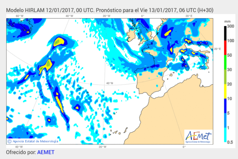
Image - Screenshot
By Friday in the north of the Iberian Peninsula they could fall from 5 to 10mm. Weak rains are also expected in eastern Catalonia and in areas of the Valencian Community.
Rain forecast for Saturday

Image - Screenshot
On Saturday the rains will continue in the north of the peninsula, and may fall up to 10mm in Cantabria and the Basque Country. In southern Andalusia they are expected to fall between 0,5 and 5mm. A few drops could also fall in the south of Mallorca.
Rain forecast for Sunday
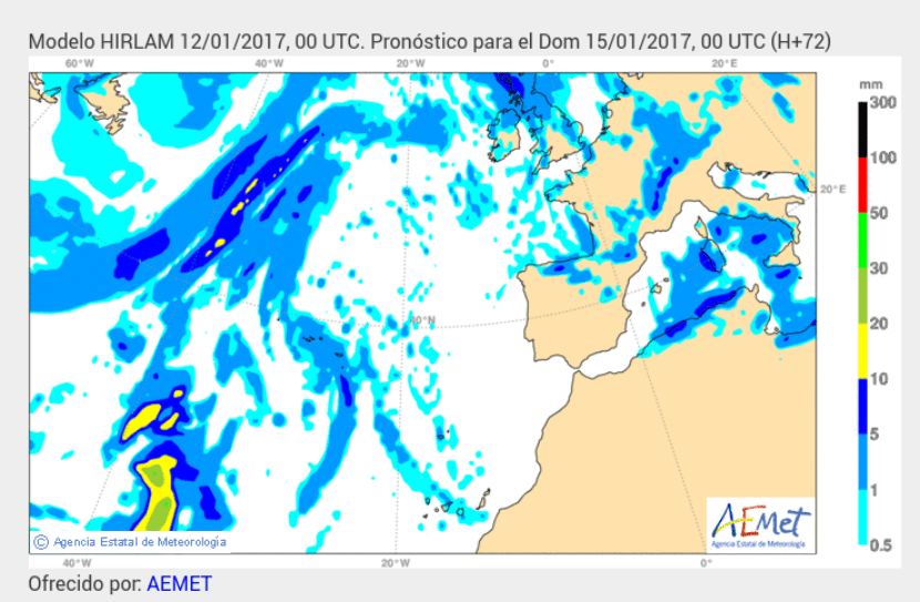
Image - Screenshot
On Sunday the situation will begin to normalize on the peninsula. The rains will continue to be weak, and the north of the peninsula is not expected to fall more than 10mm, more specifically in Asturias and Cantabria. Very weak rains could be registered in the northwest of Mallorca.
Cold
They wait North component winds that will be strong with very strong intervals in areas of the northeast quadrant and in the Balearic Islands. The snow level will be, depending on the day, between 300 and 800 meters in the extreme north. It is very likely that significant snowfalls will be recorded in the Pyrenees and the Cantabrian Mountains. But, as always, let's see it in more detail:
Temperature
Temperature forecast for Friday
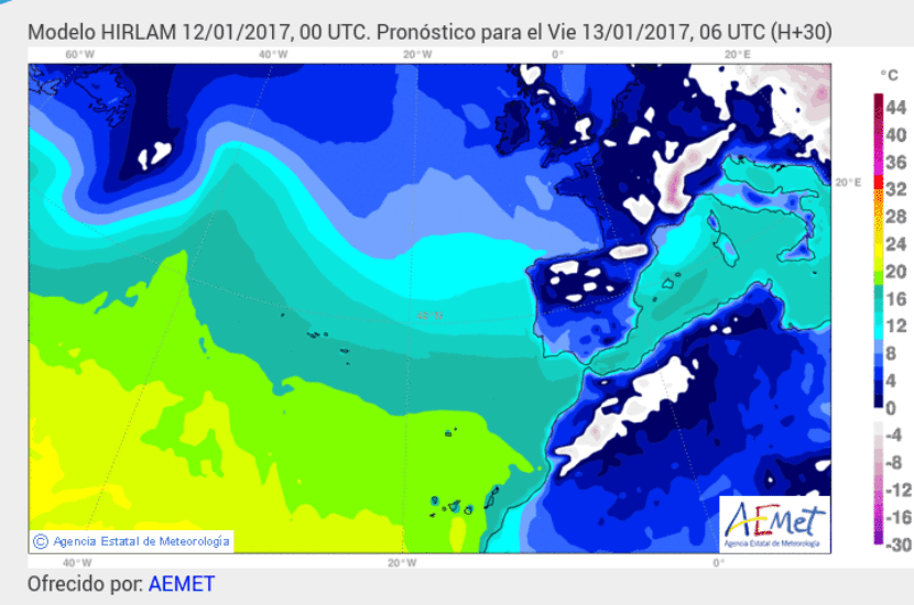
Image - Screenshot
For tomorrow, Friday, frosts of up to -4ºC are expected in many parts of the north of the peninsula: Asturias, Cantabria, north of Aragon and Catalonia, southeast of Castilla y León, and southwest of Aragon.
Temperature forecast for Saturday

Image - Screenshot
Saturday will be a cold day. Frosts are expected in much of the peninsula, which could be as low as -8ºC in northern Catalonia, and as low as -4ºC in Asturias, Cantabria, Madrid, and Aragon.
Temperature forecast for Sunday
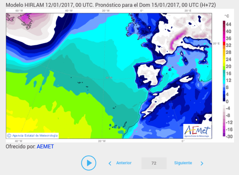
Image - Screenshot
On Sunday frosts of up to -4ºC are expected in parts of the south of Castilla y León, Madrid, parts of Castilla y La Mancha, the eastern half of Andalusia, and in the north of Catalonia.
Wind
Wind forecast for Friday
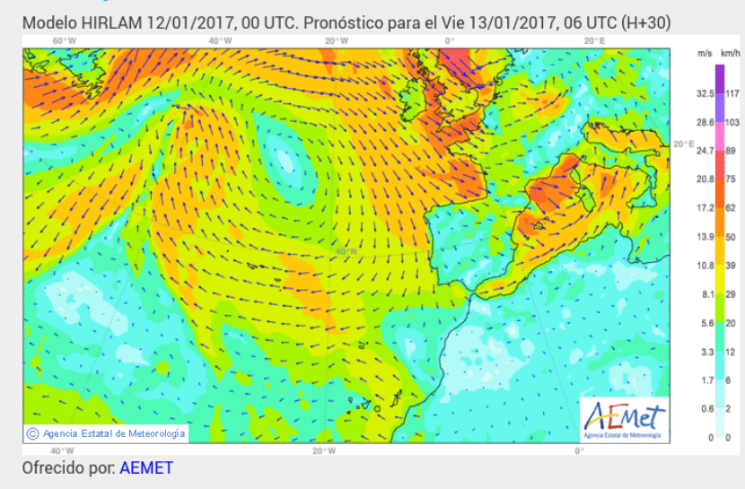
Image - Screenshot
On Friday the wind will generally be weak of up to 20-29km / h in the eastern half of the peninsula and in the Canary Islands. In the Balearic Islands the wind could be strong, up to 62km / h in the north of the islands, and up to 50km / h in the south.
The state of the sea will be bad tomorrow on the Cantabrian coast, with waves of up to 6 meters, and in the Mediterranean, with waves of 3 to 4m.
Wind forecast for Saturday
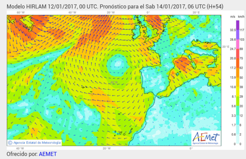
Image - Screenshot
On Saturday the wind will weaken. In the Canary Islands it will blow at around 29km / h, as in much of the Balearic Islands, where it is only expected to exceed 30km / h in Ibiza.
The state of the sea will be bad in the Mediterranean.
Wind forecast for Sunday
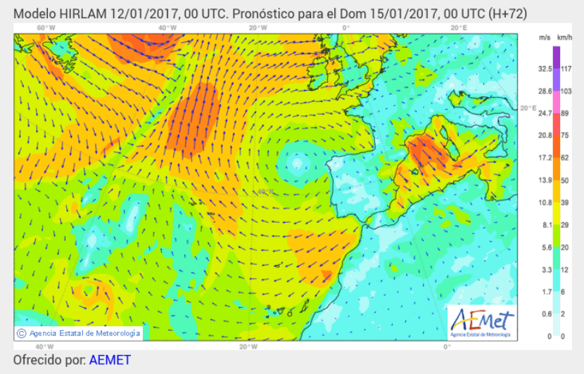
Image - Screenshot
On Sunday it will continue to weaken, although in Ibiza and Menorca it could blow very hard, reaching a speed of 62km / h.
The state of the sea will continue to be bad in the Mediterranean, with waves that could exceed 4 meters towards the northeast of Catalonia and in Menorca.
If you want to read the notice of the AEMET, Click here.
Thus, a lot of caution if you have to take the car these days. We will continue to report the news.