
Surely you have ever lived the strong summer storms. And is that during certain times of the year, environmental conditions are more likely to generate violent storms. In this case, we are going to talk about summer storms and their formation.
If you want to know how summer storms are formed and what their consequences are, this is your post.
Summer storms
When summer is around the corner, the temperatures start to rise. With this, so does the amount of air rising altitude. Let's not forget that the dynamics of the atmosphere work in a certain way. Hot air is less dense, so it tends to rise in altitude. As you reach higher altitudes, you encounter another layer of cooler air. If we look at the thermal profile of the lower atmosphere we see that the temperature decreases as we increase the height. So if hot air meets colder air when it reaches higher heights, it begins to condense.
The degree of condensation of the air depends on the temperature at which it reaches the indicated height and the temperature existing in that layer of air. If the degree of condensation in the air is strong and the environmental conditions remain stable, precipitation clouds form that can form truly intense storms.
Summer days are usually sunny and hot. However, on certain days, even if the day dawns sunny, the sky begins to darken and ends in a storm. It is the high temperatures that produce these types of storms. Let's see what the process can form the summer storms.
How summer storms form

The first of all is to analyze what the initial environmental conditions are. We start with a day with high temperatures and a sun that warms the environment. As the environment warms, so does the surrounding air. When the air is heated and its temperature increases, it tends to rise because it is lighter and expands under pressure. This hot steam that has risen to higher heights comes into contact with a cold air mass. This contrast of temperatures causes that say hot to condense into drops of water quickly. The contrast between hot and cold causes it to originate in storms that they usually last about an hour.
The problem with these types of storms is the intensity with which the rainfall falls. As a large amount of water vapor condenses and becomes droplets that form rain clouds at a rapid speed, they are precipitated by the action of gravity. Let's not forget that for water droplets can form at altitudes, hygroscopic condensation nuclei are needed. These condensation nuclei are nothing more than particles in the environment that are floating and that serve as a nucleus for the water droplets to be stored around them.
When the drops of water reach a weight that can already resist the action of gravity, it falls in the form of rain. Summer storms are usually very intense but only last about an hour. This is the time it takes for the rain cloud formed to disappear due to the action of this rising air. As the storm occurs, it continues to be fed back by a greater amount of hot air that rises and encounters other airs of lower temperature at altitude.
How to know if the storm is near
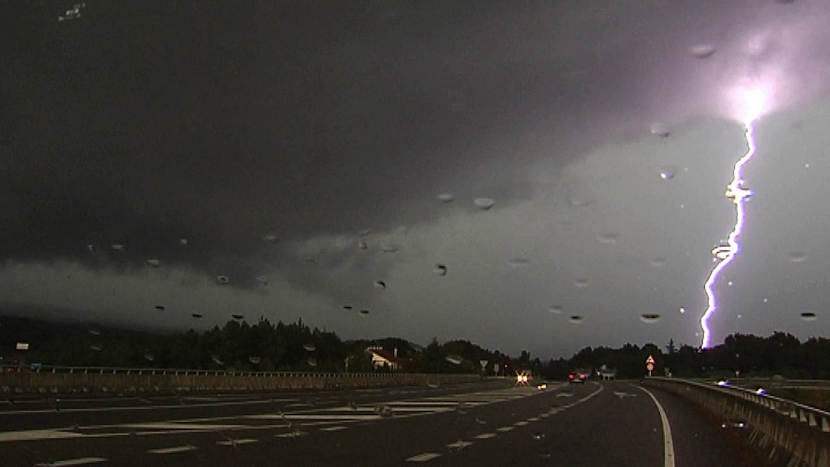
It is very common for summer storms to surprise people because they happen so quickly and unexpectedly. The lightning bolt can give us a clue as to whether the storm is near or not. It can also give us another clue as to whether or not what was approaching us are summer storms. There is a fairly simple formula that can help us learn everything about this storm.
This formula consists of looking at the lightning bolt and calculating how long it will take until the ground is heard. Lightning is seen at the very moment it is produced. However, thunder will travel at the speed of sound. This speed is 340 meters per second. Therefore, depending on the distance the storm is from us, it will take more or less to solarize that terrain. A kilometer of distance translates into approximately 3 seconds. Depending on how long it took to sound, we can predict where the summer storms are.
If about 3 seconds pass from when we saw the lightning until the thunder sounded, we can know that the storm is a kilometer away. If 6 seconds pass, it will be two kilometers. This is how, successively, we can predict where the storm is at that moment. Thanks to this type of calculation, we can flee to see this storm before it reaches us.
Dangers of storms
As we have mentioned before, although summer storms usually last a very short time, they tend to be very dangerous. This danger is due to the intensity with which they fall. We are going to give an example that usually happens frequently during summer days. We are first thing in the morning and we raise the blind seeing that it is a bright sun and a heat that encourages us to bathe in the pool. However, This intense heat can cause a storm throughout the day.
The problem is that, on occasions, it is usually accompanied by heavy hailstorms. It is the hail that causes serious material damage. Hail formation is caused by condensation occurring too quickly. This hail is what can cause material damage and agriculture, above all.
Summer storms too they are usually accompanied by thunderstorms. They are lightning bolts that constantly illuminate the sky and, therefore, it is recommended not to take refuge in trees or be in contact with metallic objects. Appliances and any electronic device that it has connected to electricity must be unplugged as they could be damaged by these storms.
I hope that with this information you can learn more about summer storms and how they occur.