
Due to climate change and the increase in global average temperatures we are having different changes in the atmospheric and oceanic patterns. In this case, the Atlantic Ocean is warning of the changes it is undergoing due to climate change. The storms in the Atlantic they are increasing and with them the formation of hurricanes and hurricane force winds.
In this article we are going to tell you which ones are the cause of the increase in storms in the Atlantic and what are the consequences of climate change in an increasingly tropicalized Atlantic Ocean.
Storms in the Atlantic
The Atlantic Ocean is warning. This is a summary of the changes in atmospheric dynamics observed in recent years that affect the north of Macaronesia, an area that includes the Azores, the Canary Islands, Madeira and desert islands, and the southwest of the Iberian Peninsula. Everything points to the region's climate turning tropical.
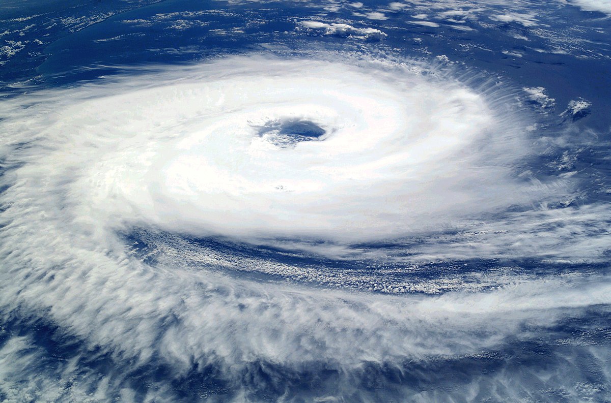
Since the historic arrival in 2005 of tropical storm Delta to the Canary Islands, the number of tropical cyclones that pass through these regions has increased significantly in the last 15 years. These cyclones are areas of severe low pressure climate and do not exhibit the typical behavior of mid-latitude storms or extratropical cyclones that we are used to in this part of the planet. Instead, they exhibit characteristics more similar to the typical tropical cyclones that normally affect the Caribbean on the other side of the Atlantic.
In fact, these phenomena increasingly resemble tropical cyclones in structure and nature. So much so that the US National Hurricane Center has increased research and monitoring of our watershed in recent years, and named a not inconsiderable group of these phenomena.
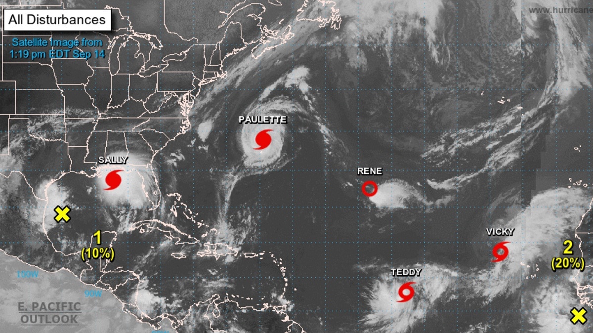
Increased storms in the Atlantic
The anomaly mentioned above has increased in the last five years. We have some notable examples:
- Hurricane Alex (2016) It occurred in the south of the Azores, approximately 1.000 km from the Canary Islands. With maximum sustained winds of 140 kilometers per hour, it reaches hurricane status and sails in an unusual way across the North Atlantic. It became the first hurricane to form in January since 1938.
- Hurricane Ophelia (2017), the first Saffir-Simpson Category 3 hurricane in the eastern Atlantic since records began (1851). Ophelia achieved maximum sustained winds of more than 170 kilometers per hour.
- Hurricane Leslie (2018), the first hurricane to arrive so close to the peninsular coast (100 km). It hit Portugal at dawn with winds of up to 190 kilometers per hour.
- Hurricane Pablo (2019), the closest hurricane ever formed in Europe.
- Like its last high tide, Tropical Storm Theta threatened the Canary Islands, just 300 kilometers from fully affecting the islands.
In addition to these cases, there is a long list that accompanies them since they are extremely anomalous and affect the aforementioned areas. In this way, the frequency has increased to once a year in the last five years, and even more than once in the last two years. Before 2005, the frequency was one every three or four years, without representing a significant danger of impact.
Anomalies in the 2020 season

This rarity is consistent with what happens during the hurricane season from June to November this year. Predictions already point to a very active season culminating in 30 cyclones, a true record. That means naming them using the Greek alphabet, beyond the historical 2005 season.
On the other hand, the season is also characterized by major active hurricanes of Category 3 or higher. In fact, it joins the first four seasons for the first time since records began (1851) that at least one Category 5 hurricane has formed in five consecutive seasons. The latter is very consistent with climate change projections, the most intense hurricanes are proportionally stronger and more frequent.
Climate change studies
It should be borne in mind that the increase in storms in the Atlantic and the tropicalization of this part of the world have to do with the effects of climate change. The answer is yes, but more research is needed.. On the one hand, we have to know the relationship with the observed events, and in Spain we still do not have the technical capacity to carry out this type of operational attribution studies that are carried out in other countries. What we can establish is a relationship based on studies of future climate scenario projections that assume that these phenomena occur more frequently in our basins.
This is where we can build relationships, although more research is needed to identify and further refine the specifics of these future events in order to improve planning for adaptation to anticipated climate change. While it is true that it is possible that never reach higher intensities such as category 3 or higherHurricanes and minor tropical storms are also a matter of particular concern due to their great impact on the US coast and it must be added that in Spain we were not fully prepared for this.
Another characteristic to consider is that they present greater uncertainty in their forecasts. Unlike the tropics, where cyclone paths are influenced by more predictable factors, as these cyclones begin to approach our mid-latitudes, they begin to be influenced by less predictable factors, increasing uncertainty. Another important aspect is the potential for greatest impact when they begin to evolve into mid-latitude storms, a transition known as the extratropical transition, which can cause them to expand their range.
Finally, it is important to also take into account the possible uncertainty in the trends inherent in the phenomenon we are talking about. While all these changes are always considered in reference to historical records from 1851, it is in fact from 1966 that these records can be considered really as solid and comparable as those of our current era, because that is the beginning of what is possible. Observe them with satellites. Therefore, this should always be kept in mind when analyzing trends observed in tropical cyclones and hurricanes.
I hope that with this information you can learn more about the causes of the increase in storms in the Atlantic.