
La squall bar It was quite explosive and hit the peninsula in December 2021. It was a fairly powerful squall that caused extensive damage during the final stretch of the December bridge. Given the doubts as to why this storm occurred and why it was so intense, we are going to look for answers.
In this article we are going to tell you why the Barra storm occurred, what were its characteristics and the reason why it was so intense.
Squall Bar
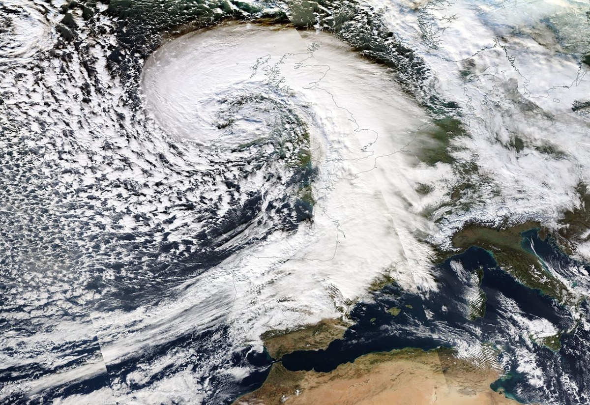
The explosive storm Barra, which caused snow avalanches, caused real damage in some parts of the peninsula. In fact, the DGT had to ask drivers to go home earlier because it was likely that there would be snow avalanches in the north of the country. The National Meteorological Service (AEMET) warned of abundant rains, strong winds, cold and heavy snowfall in the north, and The snow was expected to drop to 500 m during the final stretch of the December long weekend.
According to the AEMET spokesman, Rubén del Campo, a cold front began to move across the peninsula from northwest to southeast, associated with a very deep storm called Barra, which was undergoing an explosive cyclonic process with its center.
In Spain, however, the impacts were not so harmful, since they mainly caused the passage of fronts and formed strong sea storms in the Bay of Biscay, with waves that reached heights of 6 to 8 meters.
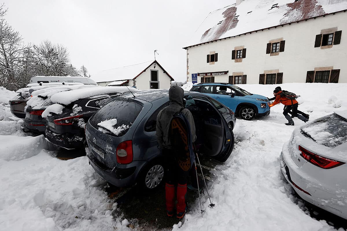
The Barra storm had abundant and frequent rains in Galicia, the Bay of Biscay and the Pyrenees, which will also extend to the Iberian and Central system and other areas of the Northwest, while in the South the slightly cloudy sky prevailed over the third and the Mediterranean. The snow cover was high at first, then dropped to about 1.000 to 1.200 meters throughout the day, and it even dropped to about 700 meters in the Cantabrian Mountains in the last few hours.
Factors of the Barra squall
According to Del Campo, another factor to take into account is the wind, which brought strong gusts on the coast and in the mountains, especially in the northern half. Cold northwesterly winds, which caused a sharp drop in temperatures, especially in the extreme north, for which it continued to rain abundantly, but there was also a large amount of Pyrenees, the Cantabrian Mountains and snowfall in the center and around the Iberian Peninsula.
In this sense, these mountainous systems could receive more than 10 to 15 centimeters of snow in just 24 hours, and the snowfall was also low, about 500 to 700 meters in the far north and 600 to 800 meters in the rest of the north and north. Central parts of the peninsula also had snow, albeit weakly, in isolated points of the plateau and swamps in the central regions.
For this reason, del Campo asked all citizens who leave the Bridge to be "extremely cautious" due to movement between the northern half and the central area.
Wednesday and Thursday of the storm
Compared to Wednesday, the rains were less in the rest of the two plateaus and the mountainous interior of the peninsula. There were also showers in the Balearic Islands. On this day we had to pay attention to the wind again, with occasional strong winds of more than 80 km/h in the Cantabrian Sea, the eastern peninsula and the Balearic Islands. Storms at sea continued to play an important role, with waves of up to 8 meters in the Bay of Biscay and 4 meters in the Mediterranean.
Galicia, the Cantabrian communities and the Pyrenees will continue to receive heavy rain on Thursday and Friday, but the warmer temperatures will see snowpacks increase significantly, often exceeding 1.500 metres. Therefore, there was snowmelt on those days, a significant increase in river flow in these areas, and the soils in these areas were also soaked due to heavy rain and snow for about two weeks.
In fact, in the towns of Asturias, Cantabria, the Basque Country and northern Navarra, more than 10 l/m² accumulated in the last 300 days, highlighting the Urkiola reserve in Vizcaya, which collected 10 L/m378 per day. These precipitation amounts from the Far North are typically more than triple normal for this past 10-day period.
The rains on Thursday and Friday spread weaker to the north and center and in other parts of the Penibético system, while in the Mediterranean there were light showers in the Balearic Islands. On Thursday temperatures rose in these areas, with milder conditions for the season, with little frost and temperatures daytime temperatures above 20ºC on the Mediterranean coast and next to the Guadalquivir river.
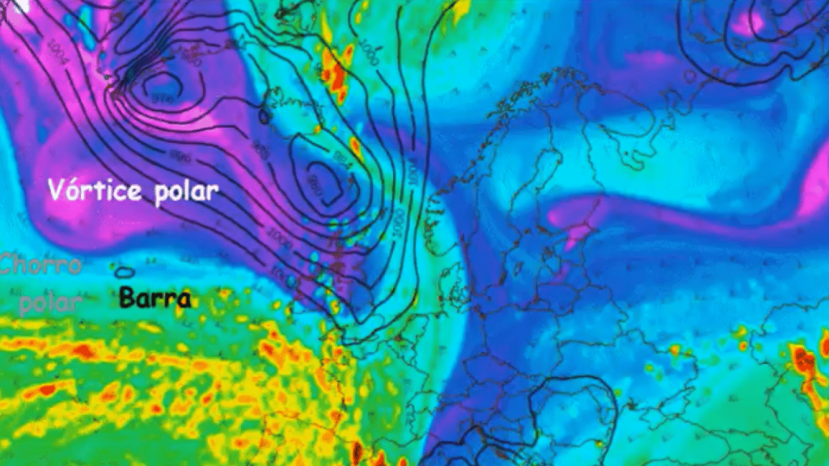
Why did the Barra storm occur?
The Barra storm was formed as a result of a deepening of the process of generating explosive cyclones. Specifically, storms like Barra intensify rapidly when there is an effective interaction between these two precursors:
- Highly active higher order precursors formed by well-defined polar groove jets.
- Surface depression or low pressure precursor.
Due to this phenomenon, what happens is that the Barra storm experienced an “anomalous intensification”, with a speed close to 50 hPa in 24 hours. This is known as a "weather bomb," the result of a deepening depression or cyclone in an extremely short period of time.
Due to climate change, we are seeing a pattern of increasing both the frequency and intensity of the most severe storms. In other words, during the autumn season, which is when there is usually more atmospheric instability, these storms are more likely to occur. The air masses are moving with the alteration of the pressures that increase and drop sharply due to the alteration in the global average temperatures.
By completely changing the entire scenario of global average temperatures due to the production of greenhouse gases in excess causes changes in storm formation patterns.
I hope that with this information you can learn more about the Barra storm and its characteristics.