
Nature is spectacular, but to see a storm cloud, that is, to be able to see a Cumulonimbus cloud and be able to contemplate it in all its splendor you have to get on a plane and have the immense luck that precisely that day a. The pilots are sure that they are used to seeing them, from so many trips they take, but sometimes they can impress, a lot.
The lucky man who took the storm photo that we are going to show you next is called Santiago Borgia, who is the first officer for LATAM Ecuador Airlines, and who at that time was in a Boeing 767-300 flying through southern Panama, at an altitude of 37.000 feet (about 11km).
With his Nikon D750, he managed to take one of the best Cumulonimbus photographs of the storm cloud ever captured to date. Of course, as he explains, it was not the result of chance: »it is true that there are many factors that cannot be controlled and they are just luck, but I've also spent years trying».
The photograph was taken just as lightning lit up the sky, which is impressive. You want to see the photo now, right? Here you have it:
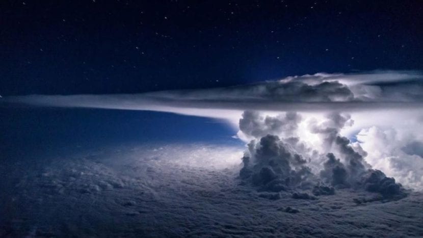
Image - Santiago Borgia
Characteristics of Cumulonimbus clouds
These types of clouds fall within the group of low clouds, since their base is less than 2 km high, but having a great vertical development, their top can reach an impressive height: 20km. They are made up of a column of warm and humid air that rises in a counter-clockwise direction.
Usually produce heavy rains and thunderstorms, especially when they manage to finish their development, as has been the case of the one that the aviator Borja has photographed.
An image, without a doubt, to look closely and enjoy it to the fullest.