
At present, there is a growing importance of society due to the knowledge of various events and consequences that adverse natural phenomena have. It is explained with a general interest in environmental matters. All this ends up being favored thanks to a greater dissemination of meteorological information through various distribution channels worldwide. With the meteosat satellite Images can be obtained through sensors installed with great detail that can provide us with a large amount of information about meteorological events that occur in the atmosphere in real time.
Therefore, we are going to dedicate this article to tell you what are the characteristics and importance of the meteosat satellite.
Advances in meteorology
Due to global change, there is a growing trend and a need to better understand the meteorological characteristics of the atmosphere. The images obtained through the sensors installed on platforms and the meteosat satellite are used to carry out actions in matter of prevention, alert, disaster mitigation and recovery of affected areas by different natural phenomena present. We know that with climate change the most extreme weather events are increasing both in frequency and intensity. This makes remote sensing an essential tool for the analysis and evaluation of natural hazards.
The meteosat satellite helps to have numerous images at a global level almost in real time that help to accept the possible consequences that can occur due to a natural phenomenon. For example, the eruption of the Icelandic volcano Eyjafjallajokull split all air traffic in much of northern Europe and forced the cancellation of flights in much of the world. This it was prevented thanks to the contribution of remote sensing using the meteosat satellite. Another case is that it represented a substantial improvement in preventing the population from the imminent arrival of explosive cyclogenesis and contributed to safeguarding material goods and reducing human losses.
Thanks to the meteosat satellite, various early warning systems have been created to warn of the evolution and appearance of forest fires. In this way, management plans can be made to end the fire and reduce damage to better protect the environment. The possibility of being able to make these fire plans is produced thanks to the new sensors that allow to capture the temperature emitted by the earth's surface.
Advantages of the meteosat satellite
With the meteosat satellite we have an information reception system when it comes to dealing with various environmental studies applied to the analysis of events related to adverse natural phenomena such as extreme atmospheric instability, volcanic emissions into the atmosphere, large forest fires, etc. We must understand that the meteosat satellite has great applications for prevention in meteorology.
To use it, various specific methods are followed and results are obtained that serve as a complement for decision-making by the competent administrations in environmental matters. Its importance is so great that it offers the necessary information to be able to prepare fairly precise meteorological predictions, ideally mitigating the probable effects of this atmospheric situation on the territory. This can be known thanks to the remote sensing of large storms and their continuous evolution.
We can also appreciate the affection of volcanic ash plumes that can be a serious global setback and cause innumerable economic losses. For example, if we can know the diffusion of volcanic ash, we can plan improve air and land transport and apply a standard methodology to observe the progress of volcanic clouds. We can also reduce or prevent environmental pollution due to the sulfur dioxide particles that remain in suspension after the volcanic eruption.
Another objective of the meteosat satellite is to be able to have a quantitative analysis of the effect of forest fires from the moment of their appearance to their extinction. Thanks to this satellite, it is possible to assess what the damages and costs to repair have been. Scientists intend to produce risk cartographies that bring together a multitude of variables that can explain the different meteorological phenomena studied and favor the prediction, management and planning tasks associated with each type of event. As you can see, It is quite useful to be able to know what is happening on our planet and have an overview of it.
Sustainable development also benefits from territorial planning thanks to the open bar for the dissemination of geographic information that is supported by various free and open software platforms.
Meteosat satellite characteristics
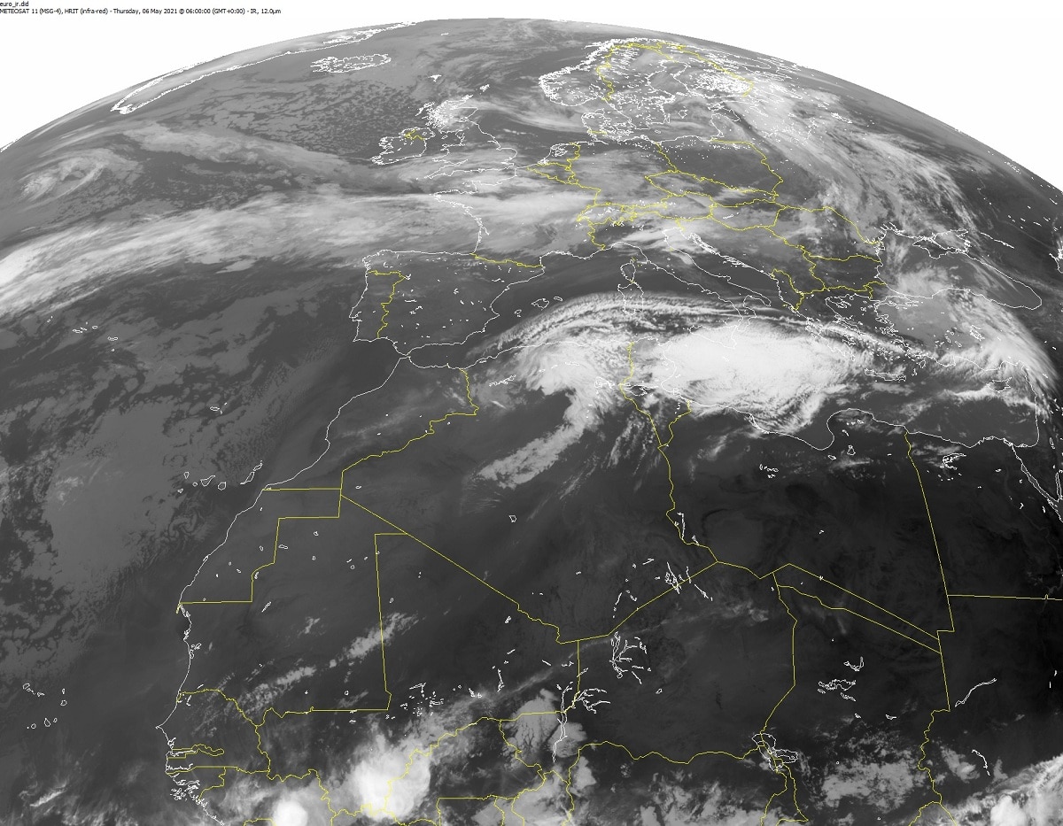
It is a series of geostationary satellites that is controlled by EUMETSAT. There is a space located at the intersection of the Greenwich meridian with Ecuador goes to an altitude of 35800 kilometers. Due to the position in which the satellite is located, it can have an orbit with a translation speed that coincides with that of the earth's rotation. In this way, we can always see the same part of the planet. It is an area that corresponds to a circle centered on the Gulf of Guinea and that covers up to 65 degrees of latitude. The Iberian Peninsula is found throughout this area and can be selected to study various meteorological aspects that may be of interest to us.
Now we are going to study the way this satellite works. It uses VIS, IR and VA images every half hour. It is capable of obtaining images every half hour so that we can have a good temporal resolution for monitoring various meteorological phenomena such as the distribution and variation of cloud cover. We know that cloudiness is one of the main aspects to know the evolution of a storm, for example. Several images are available every half hour in various electromagnetic spectra: Visible (VIS), Thermal Infrared (IR) and Water Vapor Infrared (VA) corresponding to the three types of sensors that the satellite carries on board.
I hope that with this information you can learn more about the meteosat satellite and its characteristics.