
In meteorology and weather forecasting, it is essential to know the precipitations that are going to take place in a specific area well in advance so that, if necessary, take preventive measures in a dangerous situation. To do this, there are devices that can indicate and continuously monitor the rainfall in a specific area. It is known as rainfall radar.
Do you want to know how they work and how they are used to predict rainfall?
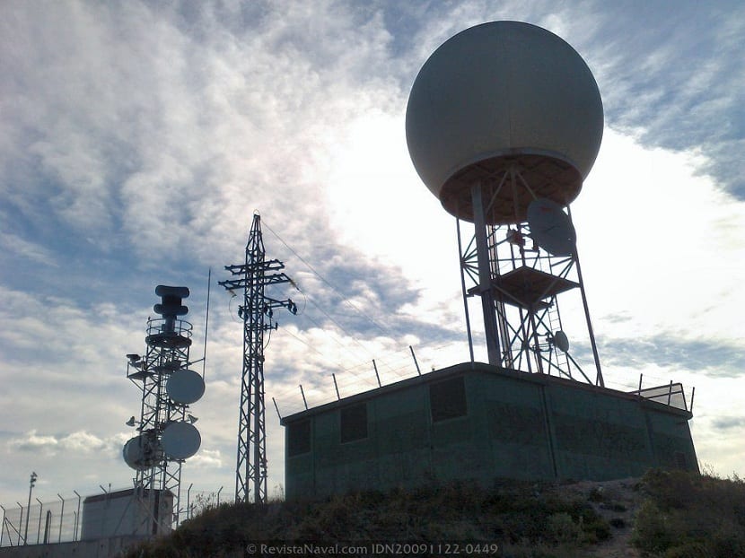
Rain Radars
For those who still do not know, the word radar comes from the English acronym radio detection and ranging. This stands for 'radio distance detection and measurement'. Radars are in many places, such as speed cameras. In meteorology, various types of radars are used to monitor the situation in the upper layers of the atmosphere and know the evolution of atmospheric systems.
The rada uses a system of electromagnetic waves to be able to measure the distances, directions, altitudes and speeds of objects, both static and moving. In this way, they are able to monitor vehicles, airplanes, ships, etc. In this case, they are used to evaluate meteorological formations and have a continuous monitoring of the movement of the clouds.
Its operation is quite simple. They generate a radio pulse and this is reflected in the target, being received from the same position of the emitter. Thanks to this you can get a lot of information about the location of the clouds, their density and shape, if they are growing, if they are going to cause some kind of precipitation, etc.
Elements of a radar
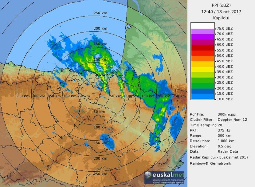
Source: Euskalmet.com
All radars need several types of elements for their operation to be correct. The use of these electromagnetic waves that the radars send allows to visualize the objects at great distances. Best of all, not only can you know the location of clouds in the spectrum of visible light, but it also provides information in sound.
The main components that radars need for their operation are:
- The transmitter. It is used to be able to generate the high frequency signals that will later be sent.
- Antenna. The antenna is responsible for sending and receiving that high frequency signal that will provide information about the position of the clouds.
- Receiver. This apparatus is used to detect and amplify the signal picked up by the antenna so that it is legible.
- A sistem that allows to show the results obtained from the measurements.
Doppler radar
Doppler radar is a system capable of measuring numerous variables on the same object. It is able to provide information about the course, distance and altitude of an object, in addition to being able to detect up to its speed. With this type of radar, meteorologists are able to know the dynamics of a cloud and thus know the course it has, its shape and the probability of causing precipitation.
Pulsed Doppler radar is based on the emission of three pulses at a certain frequency and, using the Doppler effect, the relative transverse velocity of that object to be measured can be known. Since these types of radars do not measure distances well, they are not very useful to know the exact location of the object.
Theoretical foundation of radar

Source: pijamasurf.com
To correctly understand the operation of a precipitation radar it is necessary to know the theoretical foundation. These radars act as a function of the movement of objects with respect to the radar in the component perpendicular to the direction of light. This movement produces an alteration in the frequency of the electromagnetic wave that they produce when light falls on them. That is, when sunlight falls on the object to be studied, the frequency of the electromagnetic wave that it emits is varied. With this variation, the radar is able to know the position, course and speed of the object, in this case, a cloud.
When the cloud approaches the radar it positively influences the frequency of the previously emitted waves. On the contrary, when an object moves away from the radar, it has a negative influence. The difference between the emitted and received frequencies are those that allow calculating the speed at which the object is moving.
Earth curvature
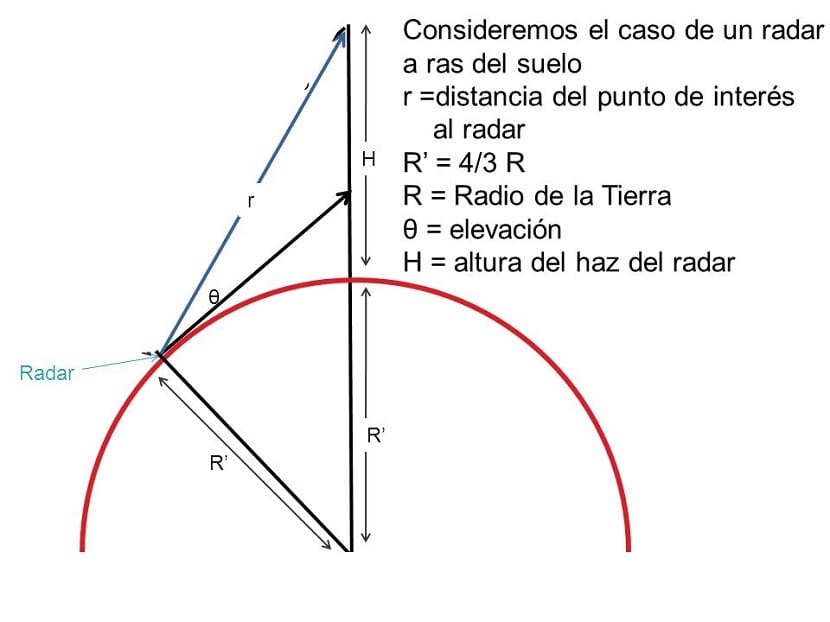
Source: Slideplayer.es
Surely you have thought that how it is able to measure the situation of objects at long distances if the Earth is round and not flat. Objects that are too far away are "beaten" by the curvature of the earth. To determine the altitude of an object, the earth's curvature must be taken into account. Objects that are more distant and close to the ground cannot be seen with this type of radar, since they are below the horizon.
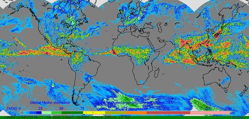
The most useful thing about this radar is that you can get real-time weather information. That is, you can know the atmospheric situation at all times to predict the intensity of rainfall, the possible existence of hail, turbulence, storms, the direction and strength of the wind, etc.
Interpretation of radar images
When measurements are made with the rainfall radar, images are obtained with all the information that is obtained. The images must be interpreted correctly for their subsequent prediction. The images have a legend on their right side that indicates the value of the color based on the reflectivity of the water that can precipitate.
Depending on the type of cloud present in the sky, one or other colors can be seen in the image:
Stratocumulus clouds. These clouds are made up of water droplets in their entirety. The water droplets are very small in size, so they give a very low signal.
Altocumulus. These mid-height clouds have a freezing level, high enough, that they are mostly made up of ice crystals and super-cooled water droplets. Ice crystals make the radar signal larger.
Precipitation. When rain is forecast, it is because in the rainfall radars it is possible to observe how the ice crystals in the atmosphere grow until they fall. Radar reflectivity increases as ice crystals melt into water because the dielectric constant of liquid water is greater than that of ice.
Stratocumulus with small drizzles. These clouds can be seen if the stratocumulus is hundreds of meters thick. When this happens, small drizzles are generated that can grow if atmospheric instability continues.
Radar of the AEMET
The State Meteorological Agency It has a rainfall radar that monitors the atmospheric situation throughout the day and night. Provides information about the clouds, their direction, speed, and altitude. Thanks to this radar, rains can be predicted up to several days in advance.
Here You will be able to see in real time the images that the AEMET radar shows us over the peninsula.
With this information you will be able to know how rainfall radars work and how meteorologists get to know the atmospheric dynamics with such accuracy.