
In the network of air currents around the world, there are different types of winds that blow more locally and continuously or more frequently, depending on the environmental conditions. In this case, the circulation of the winds that blow in Argentine territory is determined by a low pressure or cyclonic center and by two anticyclones or high pressure centers. This causes there are three local winds that blow in Argentina: El Pampero, El Zonda and La Sudestada. Do you want to know more about these winds?
Circulation of local winds
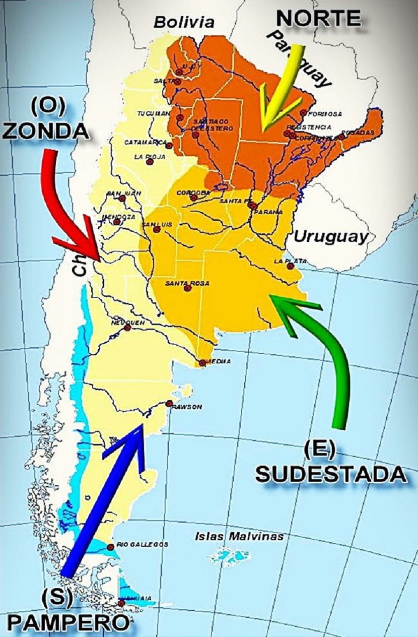
Argentina's local winds follow the patterns established by the South Atlantic Anticyclone and the South Pacific Anticyclone. The first, has its greatest influence in the north of the Colorado River. This anticyclone causes the winds to cross Argentina from the South Atlantic, crossing Brazil. Normally, the accompanying winds are warm and humid, which causes abundant rainfall in the northeast of the country and decreases as it approaches the mountain range.
The second anticyclone, that of the South Pacific, is intended to influence the Patagonia region. These winds are also laden with moisture and come from the South Pacific. This causes abundant rainfall over the Patagonian Andes. Furthermore, these winds have a second effect: act as a condensation barrier, causing the rest of the winds to arrive almost dry to the plateaus of Patagonia.
In Argentina there are factors such as latitude, relief and the circulation of winds that intervene in the characteristics of climatic varieties. It is these local winds that are affecting the climate of the different zones of the territory of Argentina. The three main local winds that blow in Argentina are the Pampero, El Zonda and La Sudestada.
The Pampero
The origin of the name goes back to the first arrival of the first Spaniards to the Río de la Plata, who were struck by a strong wind from the south-west sector that brought fresh and dry air. The ancient colonizers observed weather changes in this region very different from those that occurred in Europe.
The pampero has its origin due to a low pressure center which is located on the plains of central and northwestern Argentina. This center of low pressures is strongest in summer and can attract the winds of the South Pacific anticyclone.
When a center of low pressures is generated, for example when temperatures raise a large amount of air in height, the surrounding air masses try to replace the place that has been left with the least amount of air. Therefore, all the winds that are in the area of the South Pacific anticyclone move towards the center of low pressures.
As mentioned before, these South Pacific anticyclone winds are cold and dry, since they act as a barrier and lose moisture. It usually blows on summer days and its temperature and humidity increase due to the arrival of the trade winds.
Thus, the Pampero advances rapidly through La Pampa, establishing a storm front in the contact zone between the two masses, since they have differences in terms of humidity and temperature.
The Pampero is the cold and dry mass, while the other is warm and humid, coming from the trade winds. This contact between cold-dry and warm-humid masses cause electrical storms, abundant rains, even often with hail and accompanied by a sudden drop in temperature. When the front disappears after a while, it becomes cool and dry again.
When the air of the Pampero loses its humidity when crossing the mountain range, it is only cold and dry, it is called dry Pampero. When it causes precipitation on the aforementioned front, it is called humid Pampero. If the southwest wind does not produce rain and produces ground storms, it is called Dirty Pampero.
Pampero Forecast

To find out when the Pampero blows, meteorologists look at the high pressure system located in southern Brazil. This center of high pressure gives rise to winds that blow over the Río de la Plata and the entire north and center of the country. As these winds blow temperature and humidity are constantly increasing and pressure is high.
The wind can last between two and three days as the mass of cold and dry air that occupies all of Patagonia approaches. Once this time passes, the pressure begins to decrease gradually, while the humidity and temperature maintain quite high values). Under these conditions, a pressure drop is observed (up to 1.5 hPcal), and suddenly it is observed towards the south or towards the southwest a dark line of clouds that are advancing towards the Río de Plata. These clouds mark the front of the cold moving northeast at 20-30 knots.
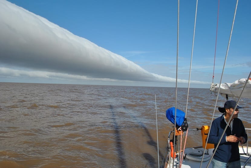
The sudestada
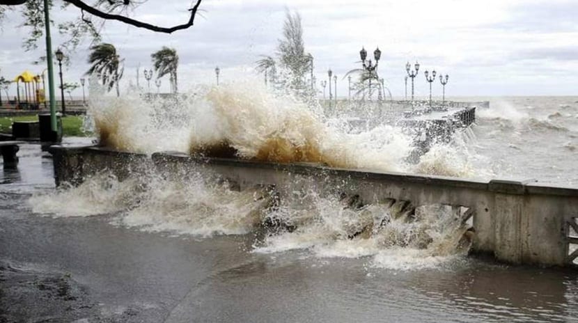
The sudestada is another type of local wind that blows in Argentina. Its origin is due to the appearance of a low pressure center on the Pampean coast. When this center of low pressures is created, it attracts all the winds that circulated in the high pressure zone in the South Pacific.
This cell in its trajectory crosses Patagonia and when it returns to the Atlantic it incorporates moisture again, which is discharged when it enters the continent again. When these rains do occur, they are usually light lasting three to five days. They do not usually go through drizzles in a continuous way during that short period.
The months in which this type of wind is most frequent is in the months of April and October.
The Zonda
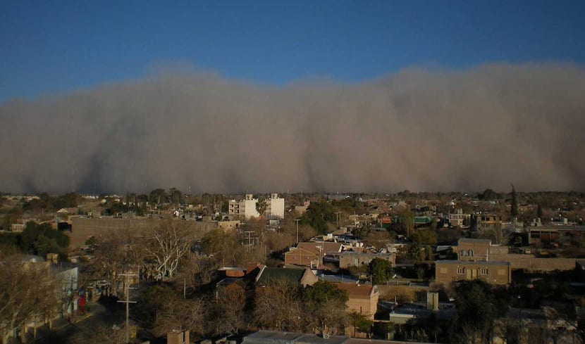
This is another local wind that blows when in the eastern sector of the foothills of La Rioja, San Juan and Mendoza, a center of low pressure is established that attracts the winds of the South Pacific Anticyclone. Its operation is similar to the Sudestada.
Once it has originated, it rises progressively as it reaches the mountain range and its temperature decreases. This causes a condensation of humidity, forming the clouds that give rise a precipitation in the form of rain and snow. Then, at a speed that can exceed 50 kilometers per hour, the wind descends down the eastern slope, causing its temperature to increase due to the friction of the air molecules against each other as they are compressed during the fall. Thus he finally reaches the foot of the mountain as a warm dry wind, with temperatures close to 40 ° C.
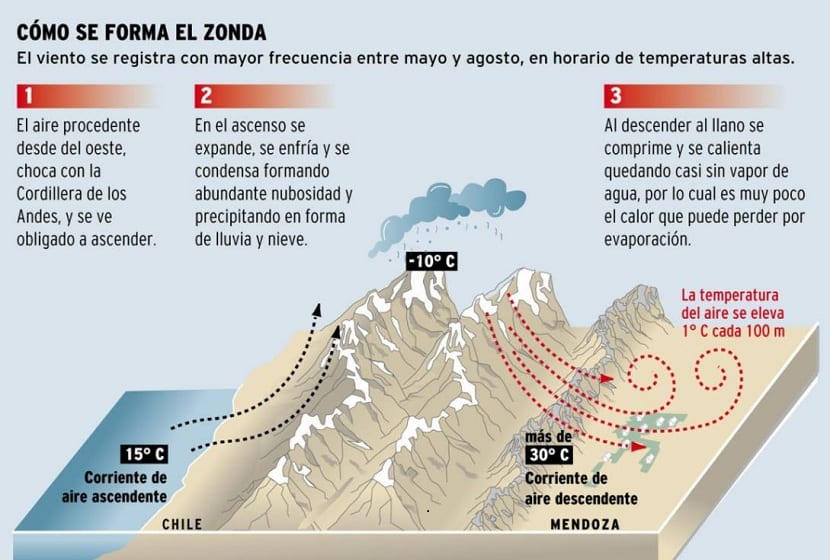
Although this wind is a bit annoying for the population, guarantees a continuous water supply for irrigation and other uses such as supply.
As you can see, Argentina is dominated by three local winds, which have characteristics that make them unique and are responsible for the country's climate.

I am writing to you with the purpose of obtaining information about the sources requested to characterize the local winds. This information will be used to carry out a research project to be carried out at the Escuela Normal Superior Dr Luis Cèsar Ingold. Hoping sincerely for your response. thanks
The prevailing wind in our hot summer in Paraná, ER, would seem to be the Pampero (although I'm not really sure). Its direction from between south and south-west can be suitable to design the natural aeration of a fifth house located on the outskirts of the city. That is, allowing the wind to pass through the entire house to help reduce the indoor thermal sensation.
The Zonda scheme is wrong. Air expands when heated and compresses when cooled. In the schema this information is reversed.
Good Morning.
The pampero and the sudestada are not winds, but meteorological conditions that occur in these areas.
What happens is that during the sporadic condition of Pampero the prevailing wind is SW. But not all SW is pampero.
The same in the very sporadic condition of Sudestada (only a few times a year) the wind is SE, but not all SE is southeast.
regards