
As we saw in the article on the inner layers of the Earth, there are four terrestrial subsystems: The atmosphere, the biosphere, the hydrosphere, and the geosphere. Within the geosphere we find the different layers of which our planet is composed. The human being has tried to deepen by means of probes to be able to study what is under our feet. However, we only managed to enter a few kilometers. Of an apple, we have only torn its thin skin.
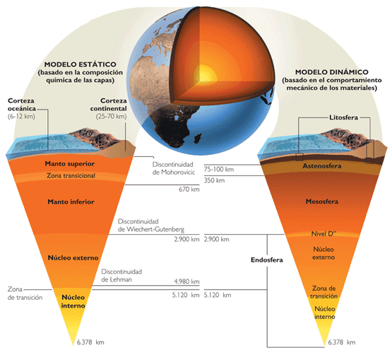
In order to study the rest of the interior of the Earth we must use indirect methods. In this way, it has been possible to arrive at two models that explain the formation of the Earth's layers according to the composition of the materials and the dynamics that follow. On the one hand, we have the static model in which the layers of the Earth are composed of: Crust, mantle and core. On the other hand, we have the dynamic model whose layers of the Earth are: Lithosphere, asthenosphere, mesosphere and endosphere.
Static model
Reviewing the static model a bit, we find that the earth's crust is divided into continental crust and oceanic crust. The continental crust harbors materials of varied composition and age, and the oceanic crust is somewhat more homogeneous and younger.
We also have the terrestrial mantle that is much more uniform in which they exist convection currents. And finally the core of the Earth, composed of iron and nickel and characterized by its high density and temperature.
Dynamic model
We are going to focus on the dynamic model. As we have previously mentioned, according to the dynamic model the layers of the Earth are lithosphere, asthenosphere, mesosphere and endosphere. Today we will talk in more detail about the lithosphere.
Source: https://tectonicadeplacasprimeroc.wikispaces.com/02.+MODEL+EST%C3%81TICO+DEL+INTERIOR+DEL+INTERIOR+DE+LA+TERRA
Lithosphere
The lithosphere is formed by what it would be in the static model the Earth's crust and the outer mantle of the Earth. Its structure is quite rigid and has a thickness of about 100 km. It is known about its rigidity at such depths since the speed of seismic waves constantly increases as a function of depth.
In the lithosphere, temperature and pressure reach values that allow the rocks to melt at some points.
According to the type of crust that the lithosphere contains, we differentiate it into two types:
- Continental lithosphere: It is the lithosphere that is formed by the continental crust and the external part of the earth's mantle. In it are the continents, mountain systems, etc. The thickness is only about 120 km and it is of an older geological age since there are rocks that more than 3.800 years old.
- Oceanic lithosphere: It is formed by the oceanic crust and the earth's outer mantle. They make up the ocean floor and are thinner than the continental lithosphere. Its thickness is 65 km. It is made up mostly of basalts and in it there are the oceanic ridges. These are mountain ranges at the bottom of the ocean in which the thickness is only 7 km.
Source: http://www.aula2005.com/html/cn1eso/04lalitosfera/04lalitosferaes.htm
The lithosphere rests on the asthenosphere that contains the rest of the Earth's outer mantle. The lithosphere is divided into different lithospheric or tectonic plates that move continuously.
Theory of continental drift
Until the beginning of the 1910th century, terrestrial phenomena such as volcanoes, earthquakes and folds were facts that had no explanation. There was no way to explain the shape of the continents, the formation of ranges and mountains, etc. From XNUMX thanks to the German geologist alfred wegener, which proposed the Theory of continental drift, it was possible to give an explanation and be able to relate all these concepts and ideas.
The theory was proposed in 1912 and accepted in 1915. Wegener hypothesized that the continents are in motion based on various tests.
- Geological tests. They were based on the correlation between geological structures on both sides of the Atlantic Ocean. That is, how the continents seem to fit together since they were once together. Pangea was called the global continent that was once united and that was home to all the species of flora and fauna on the planet.
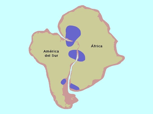
The continents fit together. Source: http://recursos.cnice.mec.es/biosfera/alumno/4ESO/MedioNatural1I/contente2.htm
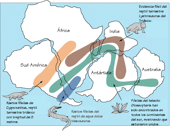
- Paleontological evidence. These tests analyzed the presence of very similar fossil flora and fauna in continental areas that are currently separated by the oceans.
Source:: http://www.geologia.unam.mx:8080/igl/index.php/difusion-y-divulgacion/temas-selectos/568-la-teoria-de-la-tectonica-de-placas-y -the-continental-drift
- Paleoclimatic tests. These tests studied the location of rocks that presented climatic conditions different from the place where they currently reside.
At first, this approach to continental drift was rejected by the scientific community as it lacked a mechanism by which the movement of the continents was explained. What force moved the continents? Wegener tried to explain this by saying that the continents moved by difference in density and that the continents, being less dense, slid like a carpet on the floor of a room. This was rejected by the huge frictional force that exists.
Plate tectonics theory
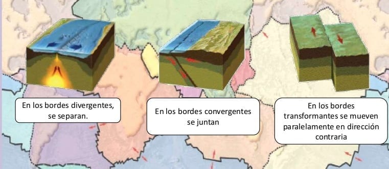
The Theory of Plate Tectonics was proposed together with all the data in 1968 by the scientific community. In it the lithosphere is the upper rigid layer of the Earth (crust and outer mantle) and is divided into fragments called plates that are in motion. Plaques change in size and shape and may even disappear. The continents are on these plates and they are moved by the convection currents of the earth's mantle. Plate boundaries are where seismic movements and geological processes occur. The lower limit of the plate is thermal. It is the collisions of the plates that generate the folds, the faults and the earthquakes. To explain the movement of the plates, different movements have been proposed. As the plates move, three types of stresses can occur at the limits between them, which originate three different types of edges.
- Divergent edges or construction limits: They are areas in which there are tensile stresses that tend to separate the plates. The area of the construction limits are the ocean ridges. The ocean floor expands between 5 and 20 cm a year and there is an internal heat flow. Seismic activity occurs at a depth of about 70 km.
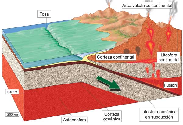
- Converging edges or destructive boundaries: They occur between plates facing each other by compression forces. The thinner and denser plate dips under the other and enters the mantle. They are called subduction zones. As a result of this, orogens and island arches are formed. There are several types of converging edges depending on the activity of the plates:
- Collision between oceanic and continental lithosphere: The oceanic plate is the one that subducts under the continental one. When this happens, the formation of an oceanic trench occurs, a great seismic activity, a great thermal activity and the formation of new orogenic chains.
- Collision between oceanic and oceanic lithosphere: When this situation occurs, an oceanic trench and underwater volcanic activity are generated.
- Collision between continental and continental lithosphere: This causes the closure of the ocean that separated them and the formation of a great orogenic mountain range. In this way the Himalayas were formed.
- Neutral edges or shear stresses: They are areas in which the relationship between two plates occurs due to shear stress due to lateral displacements between them. Therefore neither lithosphere is created nor destroyed. Transforming faults are related to shear stresses in which plates move in opposite directions and produce large series of earthquakes.
Source: http://www.slideshare.net/aimorales/lmites-12537872?smtNoRedir=1
There is a driving force caused by the heat stored inside the Earth. The thermal energy from that stored heat is converted into mechanical energy by convection currents in the mantle. The mantle has the ability to flow at slow speeds (1 cm / year). That is why the movement of the continents is hardly appreciated on a human scale.
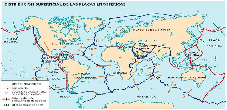
Lithospheric plates on Earth
Eurasian plate
Region east of the Atlantic Ridge. It covers the seabed east of the Atlantic Ridge, Europe and most of Asia to the archipelago of Japan. In its oceanic zone it has a divergent contact with the North American plate, while to the south it collides with the African plate (as a consequence, the Alps were formed), and to the east, with the Pacific and Philippine plates. This area, due to its great activity, is part of the Pacific ring of fire.
Coconuts and Caribbean Plates
These two small oceanic plates are located between North America and South America.
Peaceful plate
It is a huge oceanic plate that contacts eight others. Destructive boundaries are located on its margins that form the Pacific ring of fire.
Indica plate
Includes India, New Zealand, Australia, and the corresponding ocean portion. Its collision with the Eurasian plate produced the rise of the Himalayas.
Antarctic plate
Large plate that forms divergent boundaries with which it contacts.
South American plate
Large plate with a convergent limit in its western zone, very seismically and volcanically active.
Nazca Plate
Oceanic. Its collision with the South American plate originated the Andes.
Philippine license plate
It is oceanic and one of the smallest. It is surrounded by convergent boundaries, associated with subduction waves, with ocean trenches and island arches.
North American plate
In its western zone it contacts the Pacific plate. It is related to the famous San Andrés fault (California), a transforming fault that is also considered part of the fire belt.
African plate
Mixed plate. In its western limit the expansion of the ocean takes place. In the north it formed the Mediterranean and the Alps by colliding with the Eurasian plate. In it there is a gradual opening of a rift that will divide Africa into two sections.
Arabic plate
Small plate at the western limit of which the newest ocean, the Red Sea, is opening.
Source: https://biogeo-entretodos.wikispaces.com/Tect%C3%B3nica+de+placas