
There are several types of precipitation that can fall and each one has special characteristics. We have already analyzed some such as the snow and sleet. Today we have to talk about hail. Surely, more than once you have been surprised by a hailstorm in a short time. These are small ice balls that fall hard, causing damage to cities and crops and usually last for a short time.
Do you want to know how hail is formed and what consequences it has? We are going to explain it to you in detail.
What is hail

If you have ever seen hail, you have seen that it is a small hail of ice that falls in the form of a shower. It usually occurs at any time of the year and falls violently. Depending on the size of these hailstones, the damage is greater or less. These granules or ice balls consist of a solid form precipitation due to the existence of various atmospheric conditions that we will see later.
They are complete fragments of ice that fall from the sky. In some cases, the existence of gigantic balls of ice have been found, which they called aerolite. However, this does not enter into this topic, since its existence is doubtful and may be more the result of a joke than a meteorological phenomenon.
The water that is frozen in the hail usually dissolves in a short time after falling to the ground. Either due to ambient temperatures or due to the blow itself. The violence with which these ice balls fall has resulted in numerous shattering of windows, vehicle windows, impacts on people and damage to crops. The hailstorm and its danger also depends on the intensity with which it falls and how long it does. There are occasions where the hail does not fall violently, but it seems like a completely strange event. On these occasions it is not harmful.
How it is formed
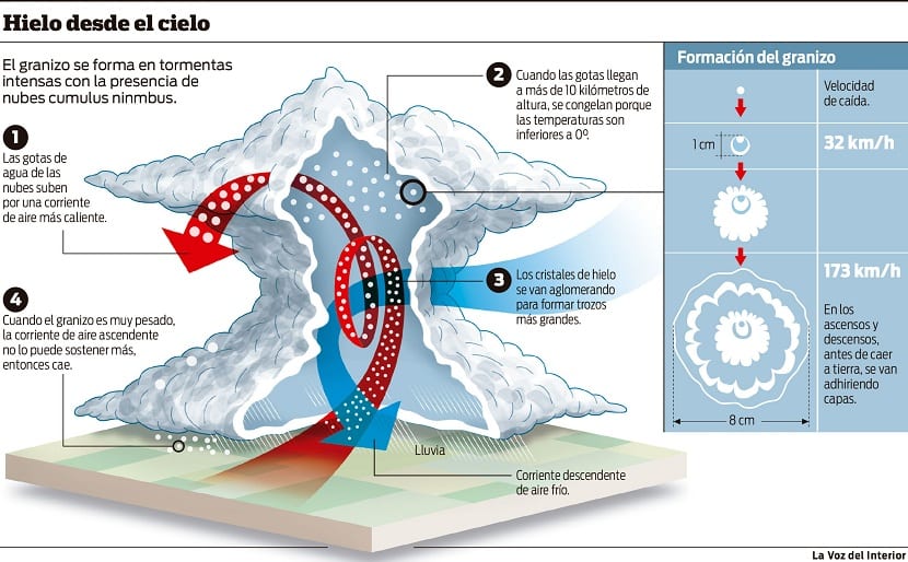
We are now going to analyze how hail is formed so that these ice balls are formed in the clouds. Hail is usually accompanied by intense storms. The clouds necessary for the formation of hail are cumulonimbus clouds. These clouds develop vertically with hot air rising from the surface. If the cold air that runs on the surface meets another mass of warm air, it will cause it to rise because it is less dense. If the ascent is completely vertical, large cumulonimbus-like clouds will form.
Cumulonimbus clouds too they are known as rain clouds or storm clouds. When the air mass is rising in height, it runs into a drop in temperature as a result of the environmental thermal gradient. As we know, the temperature begins to decrease in height as does the atmospheric pressure. Once it reaches areas where the temperature is below zero degrees, it begins to condense into small droplets of water that form clouds.
If the clouds develop vertically, it is possible to store a large quantity of these particles, generating atmospheric instability that, probably, ends up unleashing a storm. When the temperature inside the cloud is very low, not only water droplets are formed, rather, ice drops are formed. For this to form, hygroscopic condensation nuclei are needed, such as specks of dust, traces of sand, polluting particles or other gases.
If the amount of ice balls exceeds the weight of the rising air, it will end up precipitating violently under its weight.
Icing and precipitation process

Hail gradually builds up in the clouds. It is able to remain floating as there is an upward air current pushing upward and continuing to form more and more the vertically developing cloud as the hot air meets the colder part and condenses. This is how the cloud grows larger and larger. When the hail is too heavy to overcome the resistance of the updraft, it ends up precipitating.
Another way that hail occurs is for the updraft to slow down and have no resistance to be floating in the cloud. Hail is quite heavy and when it falls into the void it gains even more force until it reaches the ground. Depending on the amount of ice balls that have been formed in the cloud, we will find a more violent and lasting precipitation or less.
Different types of hail

There are differences between the size of the hail balls. Some are very small and capable of moving in the cloud. As more are formed or temperatures continue to decrease, the ice grows, as the drops approach the condensation nucleus. There are hailstones that can measure several centimeters in diameter and are the first to fall. For this reason, normally, when the hailstorm begins, is when we see the largest hailstones and they are the ones that impose the most on us. As the hail precipitation continues, the size decreases.
Among the damages that have been recorded we find a huge disaster that occurred in the Indian city of Moradabad in 1888. This hailstorm was made of complete ice stones that caused the death of 246 people by a direct impact on the head. Some died on the spot and others from the serious injuries they caused.
In 2010 the largest hail ball to date was recorded at 4,4 kilos in weight. This hail took place in Viale, Argentina. The most normal thing is that hail has negative consequences on crops, due to the destruction of the leaves and flowers as a result of its impact. On the other hand, depending on the size, it can also cause damage to the windscreen of vehicles and to some infrastructures. It all depends on the intensity and size of it.
I hope that with this information you can learn more about hail and how it is formed.