
For centuries, the fishermen of the Cantabrian Sea have been very afraid of the gale. Their short-sighted nature at the time and the high winds associated with them made them a formidable threat, with serious consequences for their fragile ships and even their own lives. Fortunately, weather forecasting has advanced and is now more predictable, although as these are local phenomena it is necessary to use mesoscale models for forecasting.
For this reason, we are going to dedicate this article to telling you everything you need to know about the gale, its characteristics and consequences.
How the gale originates
The first thing to clarify is that there are different types of gale as they can be caused by different weather conditions. Front gales are caused by the front. Since they are reflected on the weather map, they are more predictable and easier to forecast. They can occur at any time of the year and, although they mainly affect the coasts, they also reach the interior.
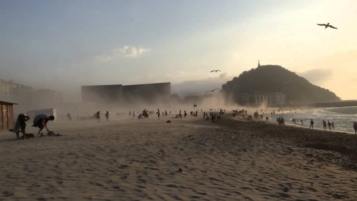
In typical high wind conditions, it only affects the coast, just a coastal phenomenon. They are typical of summer, especially on very hot days and occur after noon. They can also occur in late spring or even early fall. The key to its formation is a strong temperature and pressure gradient between the eastern and western Cantabrian. The area of low pressure in the north of the peninsula favors the presence of warm air that is quickly replaced by colder and more humid oceanic air, that is, with a northwesterly component.
The strong winds, which can last for about an hour, cover the sky with stratus clouds and fog, with gusts of between 50 and 90 km/h, and strong swells with waves greater than 2 meters, causing the thermometer to hang.
In a typical gale, we can find two climatic conditions. One is caused by barometric swamps, the other by light easterly winds. The latter is considered more dangerous because the persistent easterly winds can counteract the appearance of daytime breezes, making the phenomenon more abrupt.
Are they exclusive to the Cantabrian Sea?
The presence of a topographic barrier parallel and close to the coast, in this case the Cantabrian Mountains, It is essential during the formation of a gale. In other parts of the world, gale events with similar topographical features occur in a similar way. The Pampero wind in Argentina is an example of a sudden change in wind direction that can have similar consequences. Similar phenomena have been reported in Australia or California.
most destructive gales
Advances in weather forecasting, detection systems and early warning systems ensure that the consequences of high winds are not as present today as they were in the past.
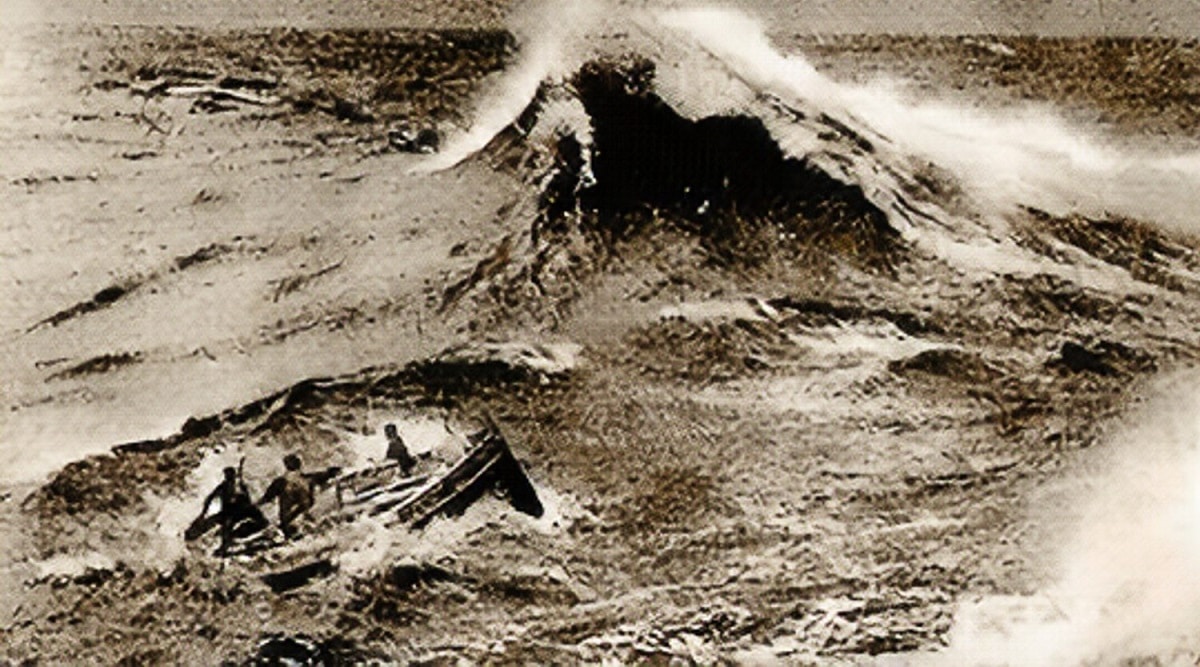
It is famous that the gale of April 20, 1878 killed more than 300 people, including fishermen from Cantabria and the Basque Country. The deadliest on record. This was followed by reports on August 12, 1912. 15 ships sank and 143 people lost their lives. It was an explosive cyclone that caused strong winds on that occasion. It was said that the communication failed as planned, and although Finisterre was informed of the weather change, the information did not reach the Vizcaya Fishermen's Association. The rest of the Cantabrian fishermen were warned not to go fishing that day, but the Bermeo fishermen did. Therefore, most of the dead came from the Biscayan town of Bermeo.
The scale of the disaster is so great that It has been recorded in history through articles, books and even documentaries.
Types of gale

Wall
- Wind: On land, the strongest winds affect coastal areas, although it also increases inland (in typical high winds, it is limited to the coast). The disturbance is parallel to the coast, affecting coastal areas (20 miles). If you leave from Asturias, the wind gusts can exceed 120 km/h. If you start from Cantabria, the gusts on the coast of Vizcaya can reach 100 km/h.
- Cloudiness: as the southerly winds blow, the number and thickness of medium to high clouds, low clouds (although not always), and cumulus and stratocumulus increases when the wind changes. The appearance of cumulonimbus clouds with normal or slightly lower atmospheric pressure is also possible, decreasing moderately as the phenomenon approaches, they do not usually descend below 1012 mbar at sea level. They can even remain stationary throughout evolution.
- Temperatures: temperatures used to be high before, and southerly winds may contribute to this increase. They drop a little before the wind changes, and then drop suddenly and quickly as the wind continues. Temperatures can drop to 14ºC in summer.
- Air humidity: the relative humidity of the air rises from 35-45% before the gale to more than 90% after the gale.
Typical
- Winds: two types of typical strong winds are identified, the barometric swamp and the smooth S circulation. In a barometric swamp, the morning and early afternoon are calm, or the southerly wind is very weak. An hour or two ago, there may be intervals of relatively warm E-component winds (sometimes alternating with intervals of S). Suddenly, the wind shifts to the northwest.
- Cloudiness: cloudy mornings with clear skies or some cirrus clouds. Fog at sea level; may also have a light haze on land.
- Atmospheric pressure: before, during and after this process, they can be completely still, although they can go down slightly. They are almost always or up to (1014 ± 1 )mb.
- Temperatures: are high or rise quickly in the morning. At noon, the thermometer can already mark 27ºC if it is June, 30ºC if it is July or August and 29ºC if it is September. Temperatures rose higher in the early afternoon. Judging by the 8ºC difference between the temperature of the air and the ocean, this situation is already a precaution. The heat is due more to the solar effect than to the advection of air masses. The temperature drop rarely exceeds the temperature levels measured in seawater. In general, in the end, the temperature of the air is similar to that of sea water.
- Air humidity: air humidity remains above 50% for several hours before a strong wind arrives. In strong winds, it can reach 90%.
I hope that with this information you can learn more about galena and its characteristics.