
For meteorology, there are several concepts that are very important. They are about convergence and divergence. If we want to increase the quality and precision of the weather forecast, we must know how to analyze these phenomena. Today we are going to work on knowing the definition of these phenomena and the dynamics it has. In addition, we are going to see how it affects time and how we can recognize them.
Do you want to know more about divergence and convergence? We are going to explain everything to you in detail.
What is convergence and divergence
When in the atmosphere it is said that there is convergence, we are referring to a crushing of the air in a certain area as a consequence of its displacement. This crush causes a large mass of air to accumulate in a specific area. On the other hand, divergence is the opposite. Due to the movement of air masses, it disperses and gives rise to areas with very little air.
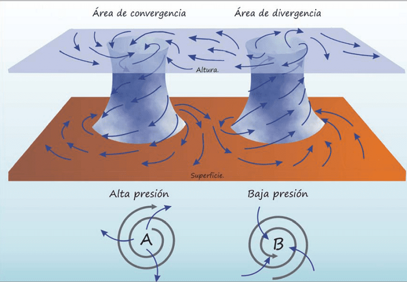
As can be guessed, these phenomena significantly affect atmospheric pressure, since, where there is convergence there will be a higher atmospheric pressure and in divergence a lower one. To understand the operation of these phenomena you have to know well the dynamics that the air has in the atmosphere.
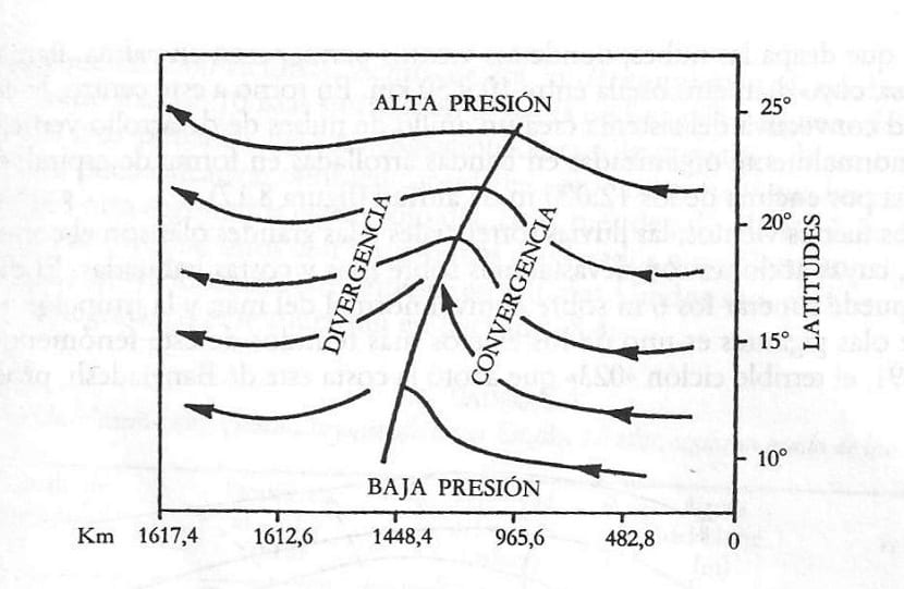
Let's imagine a region where we want to analyze air and currents. We will draw the lines of the wind direction on a map based on atmospheric pressure. Each line of pressure is called isohipsas. That is, lines of equal atmospheric pressure. At the highest levels of the atmosphere, close to the tropopause, the wind is practically geostrophic. This means that it is a wind that circulates in a direction parallel to the lines of equal geopotential height.
If in a region under study we see that the lines of the wind flow meet each other, it is because there is a convergence or confluence. Conversely, if these lines of flow are opening and distancing, it is said that there is divergence or diffluence.
Air movements process
We are going to think about a highway to have this more heat. If the highway has 4 or 5 lanes and suddenly becomes only 2 lanes, we will be increasing traffic in the area with fewer lanes. The opposite occurs when there are two lanes and suddenly there are more lanes. Right now, vehicles start to separate and it will be easier to reduce congestion. Well, the same can be explained for divergence and convergence.
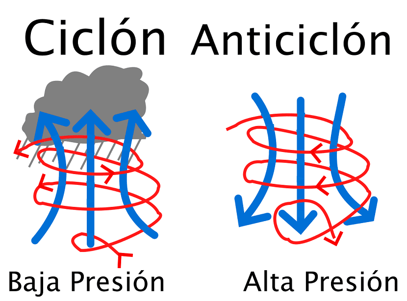
One of the situations where it is possible for there to be a vertical rise and fall of the air masses is observed when there is a relationship with the gradient wind. The speeds carried by the ascending and descending winds are between 5 and 10 cm / s. What we must think is that, in areas where there is a convergence of air, we will have higher atmospheric pressure and, therefore, the existence of an anticyclone. In this area we will have a good time and enjoy stable temperatures.
On the contrary, in an area where there is air divergence, we will find a reduction in atmospheric pressure. An area is left with less air. The air always tends to go to the area where it has less pressure to fill the gaps. For this reason, these air movements can give rise to a cyclone or synonymous with bad weather.
The friction effect that exists in the movement of the wind around high or low pressures, taking into account that the friction itself causes deviations in the direction of the wind, it is to produce divergence or convergence. That is, the component that marks the speed perpendicular to the isobars is the one that comes from the air that enters the center of low pressures or is expelled outside when there are high pressures.
Altitude divergence
In divergence, the air currents split into two flows that begin to move away in different directions. The system that governs this general circulation of the atmosphere is affected by these phenomena. When we have divergence, the winds are altered on two levels: altitude and level with the ground. The passage of air from one place to another is carried out vertically. These air movements give rise to the formation of what is known as a cell. If the convergence is lower, the air masses begin to rise in height. When they reach a certain altitude, they divide into two flows that will move in a different direction.
If these air flows begin to descend, they reach the convergence zone and, near the ground, we find another new divergence zone where it makes the air currents move in the opposite direction to the one they did at altitude. This is how the circuit or cell is closed.
The divergences in altitude usually form in the intertropical zones and in the polar regions. In these areas, air flows are affected by ambient temperatures and its density. All these movements form a system of 3 large juxtaposed cells that are giving rise to a system where the air begins to move vertically.
Experience with the wind
If experience is of any use to us, it is that when we are near sea level there is usually more convergence that causes updrafts of up to 8.000 meters in height. It is when we are at that height, at a pressure of 350 millibars, when a marked divergence begins to form.
If we see a depression or storm and we are at sea level, it is that there is convergence of the wind. This contraction of the air masses is forcing it to rise vertically, while it is cooling and condensing. As the rising air condenses, they give rise to rain clouds, especially if the rise of the air masses is completely vertical.
I hope that with this information you can learn more about the concepts of divergence and convergence and the importance it has in meteorology.
Hola!
When there is divergence of winds on the surface, the atmospheric pressure at that point is higher, since at that point there is subsidence of winds, that is, the winds are descending vertically. When these winds reach the surface they go in search of the low pressure centers, where the Wind Convergence would occur, and it is because of this low pressure that the winds can rise vertically.
However, when you write this paragraph (even in later paragraphs):
«As can be guessed, these phenomena significantly affect atmospheric pressure, since, where there is convergence, there will be a higher atmospheric pressure and in divergence a lower one. To understand how these phenomena work, one must know well the dynamics of the air in the atmosphere. "
you write the opposite process, stating that there are higher pressures where there is convergence of winds, and lower pressures in divergence of winds.
Unless you mean the Convergence and Divergence that is taking place not on the surface but up in the atmosphere. If so, I think you should clarify that, because it lends itself to ambiguities!
Similarly, excellent post!
Greetings from Colombia!