
In the sky there are different types of clouds depending on the weather conditions at that time. This type of cloud can reveal certain information about the weather. One of the best known for being storm clouds are the cumulonimbus clouds. These are clouds with a vertical development that are the ones that cause rain.
In this article we are going to tell you what the different characteristics of cumulonimbus clouds are, how they originate and what their consequences are.
What are cumulonimbus clouds
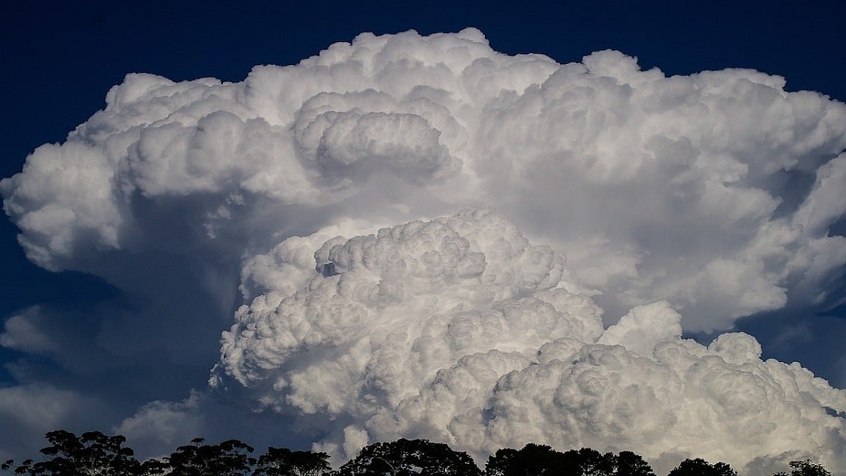
It is a dense and powerful cloud of considerable vertical dimension in the form of a mountain or a great tower. At least a part of its upper region is generally smooth, fibrous, or striped, and is almost always flat. This part usually extends in the form of an anvil or wide plume.
Cumulonimbus clouds are thick water clouds with considerable vertical expansion and development. They exhibit large-looking structures with tips that are often mushroom-shaped. They can grow to such a height that the upper layer of ice can form.
Its lower part is usually less than 2 kilometers from the ground, while the upper part can reach a height of 10 to 20 kilometers. These clouds often produce heavy rain and thunderstorms, especially when fully developed. For its creation, the simultaneous existence of three factors is required:
- The ambient humidity is high.
- Unstable hot air mass.
- An energy source that quickly lifts that hot, wet substance.
Characteristics of cumulonimbus clouds
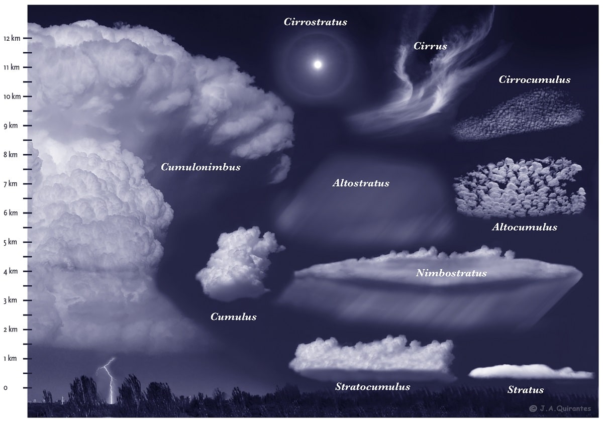
They belong to the lower stratum, but their vertical development is so great that most of the time they completely cover the middle stratum and reach the upper stratum.
are composed by water droplets and mainly ice crystals in their upper regions. It also contains large droplets of water, usually snowflakes, ice particles, or hail. Often its vertical and horizontal dimensions are so large that its characteristic shape is only visible from a great distance.
The essential difference between cumulonimbus and other clouds:
Between Cumulonimbus Clouds and Nimbuses: When cumulonimbus clouds cover most of the sky, they can easily be mistaken for Nimbuses. In this case, if the rain is of the shower type or is accompanied by lightning, thunder or hail, the observed cloud is cumulonimbus.
Between cumulonimbus and cumulus: provided that at least part of the upper region of a cloud loses its clear outline, should be identified as cumulonimbus. If it is accompanied by lightning, thunder and hail, it is also a cumulonimbus.
They are usually formed by large highly developed cumulus clouds (Cumulus congestus) whose process of transformation and growth continues. Sometimes they can develop from altocumulus or stratocumulus clouds, which contain small towering bumps on their upper parts. It can also have its origin in the transformation and development of a part of the altostratus or nimbus layer.
Meteorological significance of cumulonimbus clouds
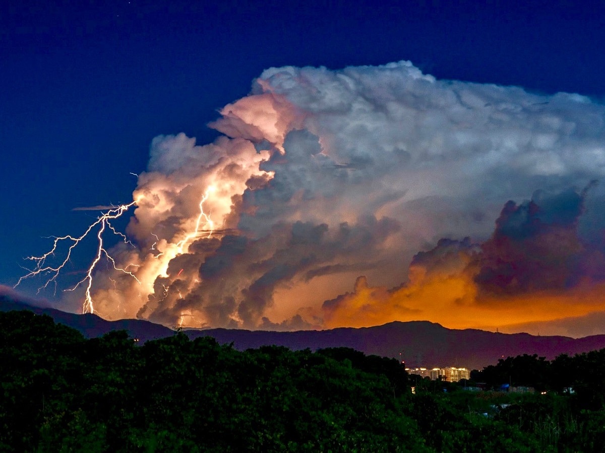
This is a typical storm cloud. In winter it is associated with the passage of a cold front, while in summer it is the result of the concurrence of several factors: heat, humidity and strong convection, which cause water vapor to rise to the upper layers of the atmosphere. and there, where it cools and condenses due to low temperatures.
Precipitation in the form of rain, hail, snow and even hail is expected. Other phenomena that accompany it are strong gusts of wind and even tornadoes when the convection is very strong.
Fortunately, with today's technology, with the help of weather radar, such clouds can be quickly detected and from there aviation and civic safety equipment can be installed.
How a cloud forms
If there are clouds in the sky, there must be air cooling. The "cycle" begins with the sun. As the sun's rays heat the Earth's surface, they also heat the surrounding air. Warm air becomes less dense, so it tends to rise and be replaced by cooler, denser air. As altitude increases, environmental thermal gradients cause temperatures to decrease. Therefore, the air cools.
When it reaches the cooler layer of air, it condenses into water vapor. This water vapor is invisible to the naked eye because it is made up of water droplets and ice particles. The particles are of such a small size that they can be held in the air by a slight vertical air flow.
The difference between the formation of different types of clouds is due to the condensation temperatures. Some clouds form at higher temperatures and others at lower temperatures. The lower the temperature of the formation, the "thicker" the cloud will be. There are also some types of clouds that produce precipitation, while others do not.
If the temperature is too low, the cloud that forms will consist of ice crystals.
Another factor that affects cloud formation is air movement. Clouds, which are created when the air is still, tend to appear in layers or formations. On the other hand, those with strong vertical currents formed between the wind or the air present a great vertical development. In general, the latter is the cause of rains and storms.
Other vertical development clouds
cumulus humilis
They have a denser appearance and very marked shadows, to the point of covering the sun. They are gray clouds. Its base is horizontal, but its upper part has large bumps. Cumulus clouds correspond to good weather when there is little ambient humidity and little vertical movement of the air. They are capable of causing downpours and storms.
cumulus congestus
It is a more developed cumulus humilis cloud and it is beginning to look much better with shadows covering the sun almost completely. At the bottom they usually turn a dark gray color due to the density they have. They are the ones that generate rains of a normal intensity.
I hope that with this information you can learn more about cumulonimbus clouds and their characteristics.