
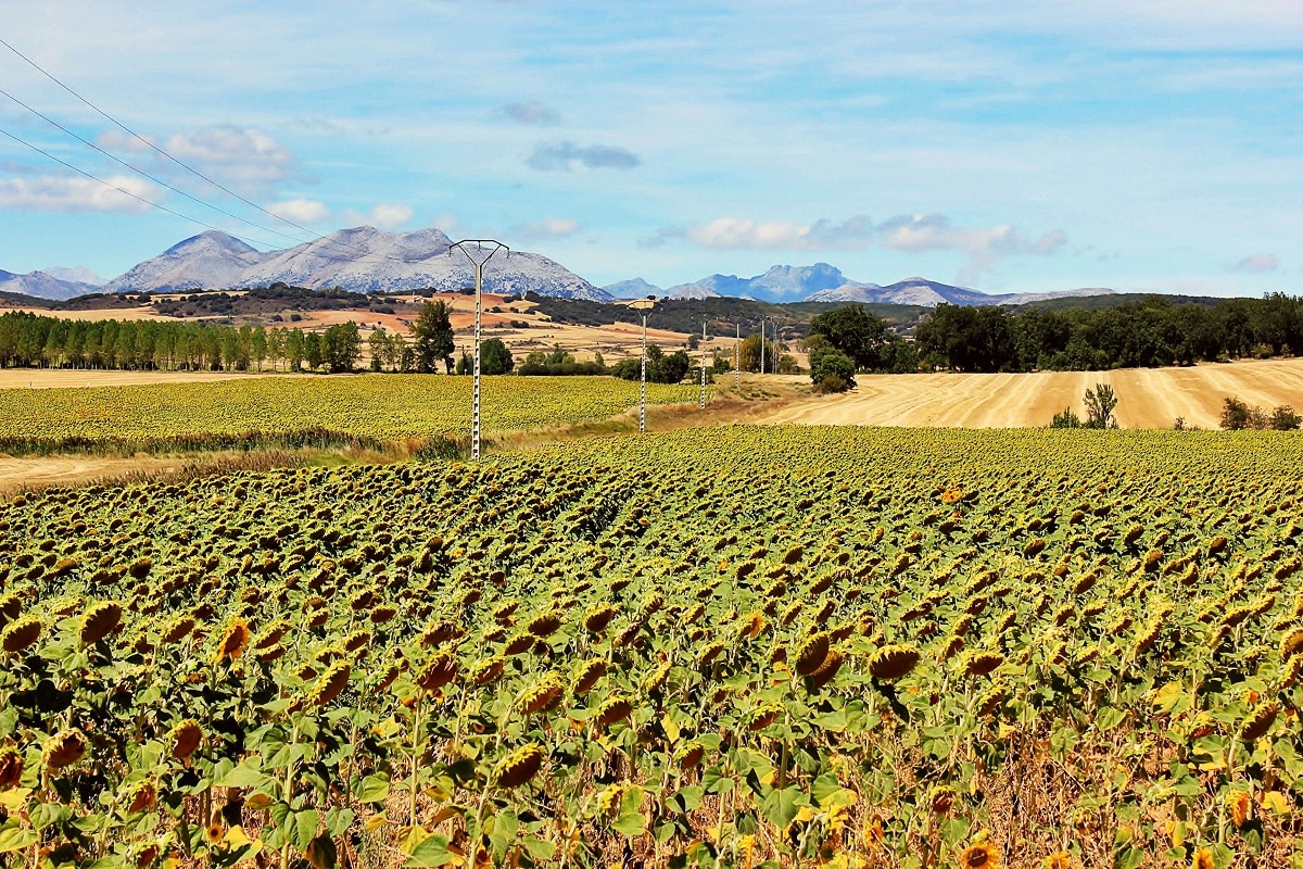
La Central Plateau It is the oldest relief unit in the Iberian Peninsula, occupying most of its surface, about 400.000 square kilometers. It is a large apple with an average altitude of 600 m. It has a continental Mediterranean climate. The central system divides it into the North Asian Plateau and the South Asian Plateau. The plateau slopes slightly towards the Atlantic Ocean, with a slope of 0,5%, and is attached to a mountainous belt that emerged during the alpine orogeny between the Cenozoic Oligocene and the Miocene, accentuating its continentality.
In this article we are going to tell you about all the characteristics, geology, climate and importance of the central plateau.
From
During the Precambrian period, it was part of the Amorica Craton, separated from Gondwana and very southern latitudes. It originated from the Hesperia block that appeared in the Paleozoic Hercynian orogeny. The massif was damaged by erosion in the Mesozoic and later altered in the Cenozoic by the Alpine orogeny and the effects of Quaternary erosion, sedimentation and ice.
During the Tertiary, the Alpine orogeny affected the old Hesperian massif, modifying its margins, giving rise to the appearance of the Galician-Leonese massif, the Leonese and Basque mountains, and the folding of its margins, such as the Cantabrian Mountains, North, Iberia, Northeast , Sierra Morena Bend Fault, South. This orogeny caused the African plate to collide with the European plate, compressing the Hesperian Massif and destroying the foundations of the Sierra de Toledo and the Central System.
In addition, the remains of the massif leaned towards the west and subsequently underwent depositional processes that were more abundant in the northern sub-plateau and the eastern sub-plateau in the south, with rivers that originate in the Iberian system. The depositional process is greater on its eastern side, while the hard, crystalline parent material of the Hesperia Massif is more evident on the western side.
The plateau, which forms part of Clay Spain, the eastern half of the North Asian Plateau, and the eastern third of the South Asian Plateau, coincides with the upper reaches of the Tagus and Guadiana rivers. On the other hand, it is part of the Spanish Siliceous, Central System and most of the western part of the South Asian Plateau.
Characteristics of the Central Plateau
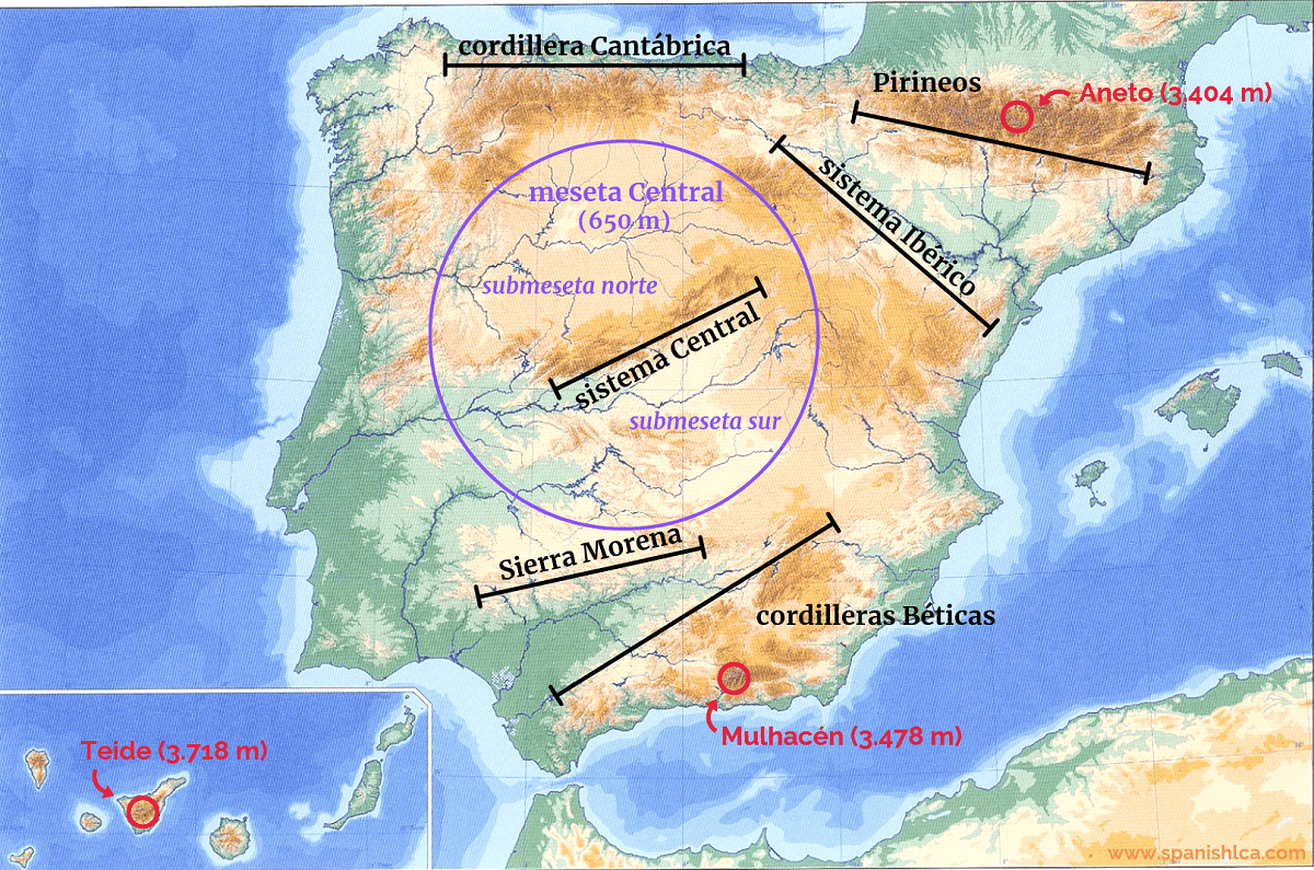
The Central Plateau is an extensive plateau within the Iberian Peninsula, surrounded by mountains that clearly configure this geographical unit and separate it from the rest of the territory. The mountains that border the Plateau in a clockwise direction are: Galicia-León, Cantabrian, Basque, Iberian System, Betic System and Sierra Morena. There are other mountains within the Plateau itself: the most important is the central system, which divides the Plateau into two halves: the South Asian Plateau and the North Asian Plateau. Montes de Toledo also subdivides the Meseta Sur into two halves: the Valle del Tajo and the Valle del Guadiana. Outside of these two mountains, there are only very small highlands or hills within Meseta, though it is mostly a vast plain.
The plateau slopes slightly to the west, which means that the waterways that run through it mostly empty into the Atlantic Ocean. The main rivers that cross the Plateau are: Duero, Tajo and Guadiana, and their numerous tributaries. On the Mediterranean side, mention should be made of Júcar and Segura on the South Asian plateau.
Climate of the Central Plateau
The extraordinary elevation of the Meseta is the reason for the existence of the entire continental Mediterranean climate. The most significant factors in this regard are: severe winters, hot summers, summer droughts, erratic rainfall, drastic temperature fluctuations, and significant droughts. These features are the result of interrelationships between a number of geographic factors and other dynamic factors, such as latitude, the region's location within the Iberian Peninsula, terrain design, and elevation.
Due to continental influences, temperatures are extremely extreme, and the annual thermal amplitude (the difference between the average temperature of the coldest and warmest months) is very high, usually between 18 and 20 °C. In July, the average monthly temperature in most of the region exceeds 24°C.
However, winter is cold, the average temperature in January in some areas is even lower than 2 ℃, and there are frequent frosts in winter, even in early spring and late autumn. Without a doubt, the northern plateau and the province of Guadalajara are the coldest flat areas in Spain. The minimum winter temperatures usually reach negative values, reaching -21 °C. 7
Although rainfall varies by region, range between 300 and 600 mm during most of the year, more frequent in spring and autumn, and very rare in summer (almost always in the form of storms). For all these reasons, most of the Meseta can be included in what is called «Dry Spain».
Relief
The rivers have been the main shapers because they deeply cut these surfaces, originating in the valleys. The witness hills (also called knots, motes or alcores) with conical or frustoconical profiles emerge as a result of the erosion processes that act on this series of horizontal formations and, eventually, as a result of anatomical inequities, as a result of the degradation of we stopped.
Although these rounded hills are usually capped by paramo limestones that protect the lower marls, sometimes the calcareous formations have been removed so that only a few limestones and boulders remain in their upper layers. Limestone dissolution process produces insoluble residues. As a result, decalcified clay deposits are formed (including limestone blocks and angular stones), terra rossa, which constitute the general lining of calcareous formations.
In the east, the formations are made up of coarse clay, and the conglomerate and limestone deposits are not very thick. Erosion is deeply embedded in this structure, forming calcareous or conglomerate platforms that protrude at various heights, it is a relief of isolated hills, structural platforms, wheels on flat surfaces, in short, it is a more than wild variety of relief. The connection of the relief of the edge of the basin with the desert is the depression of gently undulating eroded plains, formed from clay that is easier to dismantle.
In the north, the Miocene clays are covered by clastic layers from the Cordillera Cantábrica. A blanket of pebbles, gravel and sand about four meters thick also protects the weak material below. The rivers of the Cantabrian Mountains and the central system are deeply embedded in the sediments, forming wide valleys, of which the junction with the Ranaguet stands out. These flat and elevated reliefs (900-1000 m) are called rañas moors and are also common in the Sierra de Toledo. Where the paramo de rañas disappeared, reliefs of hills, hills and hills were formed, the edges of the valleys were steep, with landings, ravines and ravines.
I hope that with this information you can learn more about the Central Plateau and its characteristics