
Today we are going to talk about Betic system. Geographically, this group of mountains extends from the Gulf of Cádiz to the Valencian Community and the southern coast of the Balearic Islands. To the north, they border the Guadalquivir Basin and the southern edge of the Iberian massif and the Iberian System, while the Alboran Sea is located on the southern edge. However, like the Pyrenees, in a geological sense, it extends beyond geographical limits, extends south and northeast under the Alboran Sea, and part of its structure is not interrupted by the bottom of the Mediterranean. and part of the Balearic promontory to the island of Mallorca.
In this article we are going to tell you everything you need to know about the Betic system, its characteristics and its importance.
Key features
The mountain range is the result of a compression mechanism that began at the end of the Cretaceous about 100 million years ago and it mainly affects the northern and southern edges of the Iberian Plate. Its structure and subsequent evolution are complicated because it is the result of the interaction of two large plates and a continental block, today the Alboran microplate, which forms the inner belt of the mountain range, moved westward and finally collided with the Mesozoic margin. Iberia and northwestern Africa, forming the Betica-Rifeña mountain range.
One of the most remarkable facts at the cortical level is that no type of root is detected under the mountain range, as is the case with other alpine orogenic systems. Although some thickening of the crust can be observed, it does not exceed 40 kilometers in any of the cases. Another remarkable fact at the cortical level is the rapid thinning that can be observed in the area over the coast. where the thickness of the crust is around 22 kilometers. The area as well, continuing towards the interior of the Alboran Sea basin where it already reaches its minimum, being 15 kilometers thick.
Structure of the Betic system

Given these characteristics of the cortical domain and the use of some petrological and structural criteria, it has led to distinguish the Betic system as in the Rif two large areas as well differentiated children and separated through a tectonic contact. Furthermore, these two areas have a different paleogeographic origin. Let's see what these two areas or domains are:
- South Iberian Domain or External Zones: These areas are different in both mountain ranges and are formed by Mesozoic and Cenozoic rocks that are straddling each other and folded without having any type of metamorphization that corresponds to the sediments of the marine basin of the Tethys ocean.
- Alboran Domain or Internal Zones: these zones are composed. Stacking of landslide mantles with materials that are essentially metamorphic. The origin is related to the migration of the Alboran microplate that is located further east.
In addition to these large areas, we can distinguish the Betic system other areas such as the following:
- Furrow of the Flyschs of the Campo de Gibraltar: no domain entity is attributed to it since the type of crust on which it is located is almost completely unknown, it is common in both mountain ranges and is located on both sides of the Strait of Gibraltar.
- Postorogenic Tertiary Depressions: these depressions are made up of neogene and quaternary sediments. Most of these sediments have been produced by the erosion of the reliefs in the surrounding area. It differs mainly in different marginal basins 3030 30 to the mountain range -Depression of the Guadalquivir- and other intramountain areas -Depression of Granada, Guadix-Baza, Almería-Sorbas, Vera-Cuevas de Almanzora and Murcia mainly.
- Neogene-Quaternary volcanism: It is represented in the area of Cabo de Gata and Murcia. This volcano and does not correspond to postogenic volcanic manifestations related to recent tectonics due to numerous plate shifts.
Areas of the Betic system
We are going to analyze the areas of the Betic system and their characteristics. We start with the external area.
External zone
They are Mesozoic and Cenozoic sedimentary rocks, mostly of marine origin, formed in the Tethys basin on the continental margin of southern Iberia, and deposited in alpine folds. They occupy a great extension of the mountain range and represent the time interval from the Triassic 250 million years ago to the Miocene.
They present a structure characterized by a general detachment between the basement (Paleozoic varisco) and the deformed rock (folds, faults and pushed mantle). The Paleozoic basement does not emerge and remains at a depth of 5-8 kilometers, formed by rocks similar to the Iberian Massif. From the original location of the reconstruction unit, an original basin with a horizontal extension 2-3 times greater than the current one.
Deformations of different ages are observed. During the Jurassic period, structural instability occurred that resulted in the division of the Tethys Basin into regions of morphological differentiation. The push began in the Cretaceous and continued in the Paleogene. The final and main stage of the deformation occurred in the Miocene, which led to a widespread uplift of the mountains.
Internal zone
It is located at the southern end of the Betica mountain range, extending from Estepona (Malaga) in the west to Cape Santa Pola between Murcia and Alicante in the east.
The paleogeographic area of the interior originated further east and was part of the Alboran or Mesomediterranean microplate. With the closure of the ancient river Tethys, this separated microplate from northeast Africa migrated laterally due to transformation movements. Paleozoic rocks appear in the interior area of this microplate, which was initially folded during the Varisca orogen, and was eroded and reactivated during the Alpine Orogeny.
There are almost no Mesozoic rocks in the internal zone, generally corresponding to sediments deposited around microplates or during their migration and subsidence stages. The Triassic is different from the rest of the Betic system, since its base is made of clastic rock and the rest of dolomite. The rocks of the Jurassic and Cretaceous are carbonate rocks. In general, except for some discordant Eocene patches in the mantle, Paleogene sediments are missing.
I hope that with this information you can learn more about the Betic system and its characteristics.
Good morning:
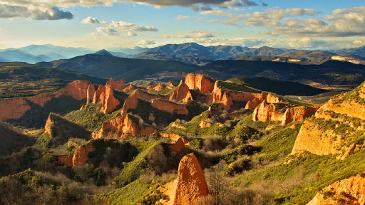
The second photo seems to me to be the landscape of Las Médulas, in León. I'm still wrong, but I think it would be worth checking.
A greeting.