
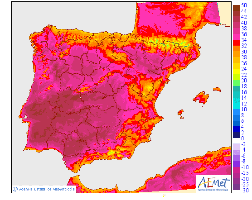
Passing hot? For a couple of days temperatures in Spain are reaching temperatures that are more typical of July / August than the second half of June. Temperatures that will rise to 42 degrees Celsius in many regions, as is the case in southern Andalusia or Castilla La-Mancha.
Although summer officially begins on June 21, it seems that this year it is six days ahead, which is a problem, especially for children in school hours. Fainting in schools has been noticia. When it's so hot, the most important thing is to cool off, especially when it comes to minors. This is the weather in Spain these days.
What time is expected for today?

Maximum temperatures forecast for Friday June 16, 2017. Image - AEMET
On June 14, the State Meteorological Agency gave the warning: a heat wave could affect the southwest quadrant of the peninsula and the central area of the peninsula, with a degree of probability greater than 80%. The start date was June 15, and the end date was next Monday, June 19. And so it has been.
Today in the provinces of Córdoba, Granada, Huelva, Jaén and Seville today are on orange alert (significant risk) due to maximums that will range between 38 and 41ºC, while in Cádiz there is a yellow alert (risk) for values of 38ºC, due to the Levante wind in areas of the Strait and due to coastal phenomena.
Castilla La-Mancha has an orange warning for temperatures that could be up to 40ºC in the valleys of the Tagus and Guadiana. On the other hand, Madrid maintains the orange alert in the metropolitan area, with values that could be up to 39ºC; and en Extremadura continues the orange warning for maximums of 42ºC.
And for the next few days?
-

- Temperatures forecast for Saturday June 17, 2017. Image - AEMET

-
- Temperatures forecast for Sunday June 18, 2017. Image - AEMET
Over the weekend both the Iberian Peninsula and the Balearic Islands will continue to be red hot. On Saturday temperatures will continue to rise in the north of the Peninsula, and on Sunday they will rise a little more in the Alto Ebro and in other northern areas. In the southeast of the peninsula and in the east of the Balearic Islands, temperatures will begin to drop.
And in the Canary Islands?
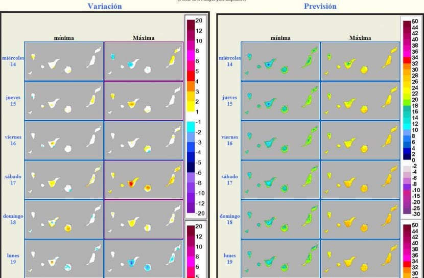
Image - AEMET
The lucky islands they seem to get rid of the intense heat a bit. The maximum temperature is around 30-32ºC, and the minimum is 10-12ºC. No big changes are expected these days.
So nothing, a lot of water and wait for the wave to pass 🙂.
Mystery of the disappeared noctilucent clouds or CEN and the COMPLICATED ORIGIN OF THIS ANTICIPATED WAVE OF HEAT:
June 15, 2017 - In late May 2017, observers in Europe began to see electric blue tendrils snaking across the western horizon at sunset. The summer season of noctilucent clouds (CEN) was apparently beginning. Odd-looking clouds typically increase their visibility in the weeks immediately after their first sighting. This year, however, something mysterious happened. Instead of going higher, the clouds disappeared. During the first two weeks of June 2017, ZERO images from CEN were received on Spaceweather.com - something that has not happened in almost 20 years.
Where did they go? Researchers have simply discovered: There has been a "heat wave" in the polar zone of the mesosphere, a region in Earth's upper atmosphere where CENs form. Relatively warm temperatures have wiped out the clouds.
Lynn Harvey of the University of Colorado's Laboratory for Atmospheric and Space Physics made the discovery using temperature data from the Microwave Probe aboard NASA's Aura satellite. "At the beginning of May, the summer mesosphere of solar radiation was cooling, as usual, approaching the low temperatures required for CEN," she says. "But don't you know? Just after May 21st, the cooling in temperature stopped over the north pole! In fact, it warmed by zones a degree or two higher over the next week. The warming translated into 2017 being the WARMEST summer in the mesopause in the last decade. "
She is describing the red curve in this plot of 10 years of evolution of polar mesospheric temperatures:

The warm temperatures at these heights are dire for the CEN. Ice clouds form 83 km above Earth when the air temperature drops below 145 K (-128 C), allowing sparse water molecules to gather and crystallize into specks of meteor smoke. Even a couple of degrees of warming is enough to destroy fragile clouds.
"We do not know why the mesosphere has warmed, but all indicators point to the increased arrival of external Cosmic-Rays to the Solar System," says Cora Randall, of the University chair in the Colorado Department of Atmospheric and Ocean Sciences. “It is probably a complex process that also involves the propagation of atmospheric gravity waves, which affect the flow of air in the upper atmosphere. We are looking at it and so it is also interrelated with the current Solar-Cycle which is abnormally low. "
Meanwhile, the heat wave may be coming to an end. "In the last week, the north pole mesopause has started to cool down again," says Harvey. This means that the CEN before returning will recover quickly, as temperatures continue to drop in that area of the north pole atmosphere. Sky High latitude watchers should be on the lookout for electric-tendrils crawling out of the setting sun on the nights that follow ahead of summer