
The growing need to know the geographical space has led human beings to discover new ways of capturing the territory. These shapes try to represent the surface of the earth thanks to precise information that can be obtained thanks to technology. Various systems have been created to achieve these purposes. Among them are the orthophoto. It is a type of photogrammetric method that is based on the use of photographic covers obtained through airplanes that are equipped with special aerial cameras. This photograph gives rise to a whole process of making charts and plans at different scales that are used by many users.
In this article we are going to tell you what the orthophoto is, what are its characteristics and how important they are.
What is the orthophoto
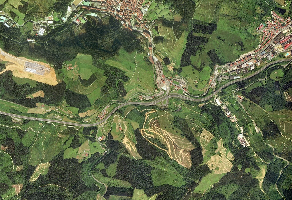
As we have mentioned before, there are airplanes that are prepared with special aerial cameras to photograph the earth's surface. These photographic covers originate a process of drawing plans at different scales that are made for multiple purposes. In addition to this model for obtaining aerial photos, various orthophotos of proven qualities are made in various parts of the world. The photogrammetric coverage responds to the need to be able to solve numerous problems of geographic space. This is one of the most accurate models to be able to show the real physical space and help to solve problems from the specialist's office.
The use of the orthophoto has become increasingly widespread in the professional field of all branches that deal with earth sciences. The realization of an orthophoto and its application in the socioeconomic development of a country is of great interest. And it is thanks to this type of information that the needs of studies, planning and a large number of professionals can be satisfied.
Key features
The orthophoto is a photographic image of the terrain whose central projection has been transformed into an orthogonal projection. In this way, with this transformation, it is possible to eliminate all planimetric distortions that are caused by the inclination of the aerial camera. There are also different distortions caused by displacement of the relief. This eliminates the scale variation existing in the un-rectified frame. These variations are due to the differences that exist in the level of the photographed terrain and the inclinations that the cameras may have at the time of taking the photo.
Thanks to this method of obtaining information, a single and exact scale can be achieved for the entire surface of the orthophoto. In order to transform a central projection to another orthogonal, which is useful, the procedure called rectification is used. It is a process that attempts to correct the variations in slopes that a terrain presents and the degree of inclination of the camera with respect to the terrain. If this difference is significant, rectification is in charge of correcting the stereoscopic model through elementary lines according to the unevenness of the terrain.
Once this information has been obtained, to the orthophoto altimetry information, a UTM grid and toponymy are added. A derivative of the orthophoto is the orthophotoplane. It is an urban sector to which the toponymy and some conventional symbols are added on a grid. It usually serves to identify all the elements of an urban ecosystem.
Uses of the orthophoto
It can be used in almost all activities where aerial photography and systemic or regular mapping are required. The advantage of the orthophoto is that it can achieve high accuracy that allows monothematic studies to be carried out quite easily. These studies can be combined with other socio-economic plans in a region.
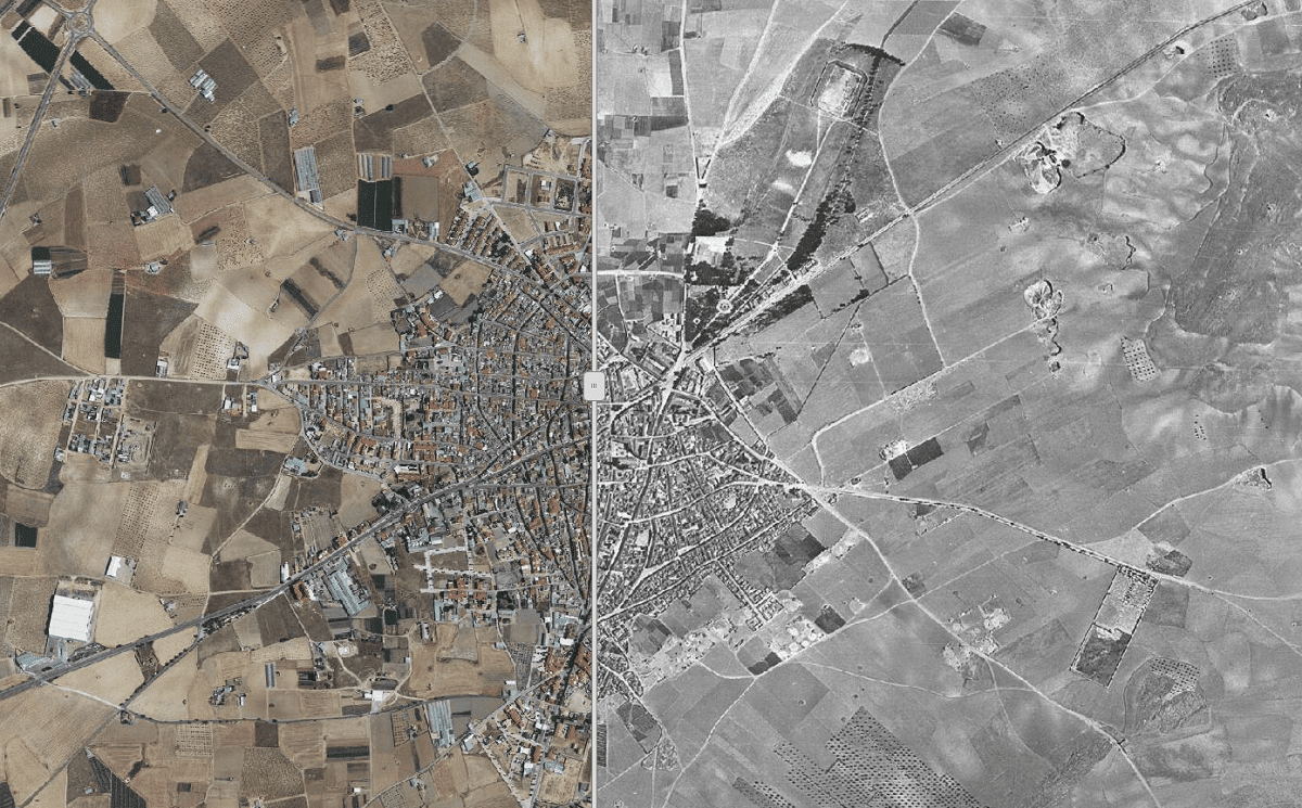
Another of the additional advantages that orthophotography offers is that it can make bases of plates or magnetic data storage tapes. Thanks to this, it is possible to easily compile a statistical compilation that can record all the changes that a certain area has undergone over time. In this way, we can have information not only on the current relief but also on the change that has had a relief over time.
In many countries, good results have been achieved with the application of orthophotos. It is worth mentioning that there are socioeconomic plans where there are more than 12.000 orthophotos at different scales. In the United States, orthophotos are used to complement all maps and obtain more information. It can also be used to obtain data on land ownership or characteristics. Orthophotos can be used to divide the different uses that a soil can have, be it agricultural, forest or urban, among others.
Among the uses of orthophotos we find prosecutors. Additionally, the use of this information for other purposes such as planning and zoning is foreseen. Thanks to the fact that it can complement the information obtained from the maps, it can be used to improve public safety and traffic control or, fire zone protection, aid law enforcement, It has various purposes of public utility, controls the land and its property and the sale of properties and plans can be negotiated thanks to the orthophoto.
Scope of natural resources

One of the areas where the use of orthophoto is most widespread is in natural resources. Orthophotos are used by natural resource information centers, forestry companies, and various corporations to obtain information on natural resources. It has also been used for the historical development of land use, general land uses, and crop identification.
May study grasslands and meadows or do phytosanitary investigations of specific crops. Many of the crop rotation systems are also determined by studies using orthophotos. Finally, it is quite interesting to see that it has applications for the estimation and forecasting of crop yields, the statistical evaluation of crops, poor soil exploitation and various studies for the classification of land.
I hope that with this information you can learn more about the orthophoto and its uses.